
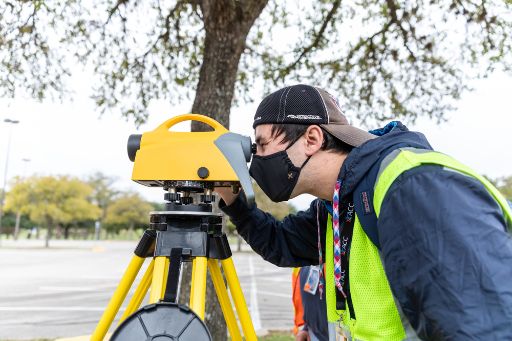
Learn to analyze spatial data and create informative maps by studying Geographic Information Systems (GIS) at Austin Community College. You’ll use industry software to visualize everything you want to know about a place—from its average household size to its most common vegetation.
Career & Salary Information
Demand for GIS professionals is expected to grow in the coming years. After completing ACC’s program, you’ll be prepared to enter the workforce or continue your studies at a four-year university.
Awards & Program Maps
Choose the Award Path That’s Right for You
ACC offers stackable credentials. Certificates prepare you for a career change or career advancement and often include credits that count toward associate degrees. Associate degrees further increase your employability and help you build a strong foundation for university transfer. Learn about credential options.
Explore awards and follow the program maps below to stay on track.
This program has Fast Track Career options that let you skill up with an in-demand career certificate that employers are looking for. See awards below for Fast Track options.
| Award Title | Award Type | Award Plan | Program Map |
|---|---|---|---|
| Accounting Specialist | Associate of Applied Science Degree | https://www6.austincc.edu/cms/site/www/awardplans/awardplan.php?year=2024&type=CC&group=PCACC&apid=8041 | https://www6.austincc.edu/cms/site/www/catalog/programmaps/programmap.php?ap=8041&yr=2024 |
| Accounting Technician Full Charge Bookkeeper | Associate of Applied Science Degree | https://www6.austincc.edu/cms/site/www/awardplans/awardplan.php?year=2024&type=CC&group=PCACC&apid=8442 | https://www6.austincc.edu/cms/site/www/catalog/programmaps/programmap.php?ap=8442&yr=2024 |
| Tax Specialist | Associate of Applied Science Degree | https://www6.austincc.edu/cms/site/www/awardplans/awardplan.php?year=2024&type=CC&group=PCACC&apid=8387 | https://www6.austincc.edu/cms/site/www/catalog/programmaps/programmap.php?ap=8387&yr=2024 |
| Accounting Specialist | Advanced Technical Certificate | https://www6.austincc.edu/cms/site/www/awardplans/awardplan.php?year=2024&type=CC&group=PCACC&apid=8374 | https://www6.austincc.edu/cms/site/www/catalog/programmaps/programmap.php?ap=8374&yr=2024 |
| Information Systems Auditor | Advanced Technical Certificate | https://www6.austincc.edu/cms/site/www/awardplans/awardplan.php?year=2024&type=CC&group=PCACC&apid=8513 | https://www6.austincc.edu/cms/site/www/catalog/programmaps/programmap.php?ap=8513&yr=2024 |
| Professional Accountant | Advanced Technical Certificate | https://www6.austincc.edu/cms/site/www/awardplans/awardplan.php?year=2024&type=CC&group=PCACC&apid=8046 | https://www6.austincc.edu/cms/site/www/catalog/programmaps/programmap.php?ap=8046&yr=2024 |
| Accounting Technician Bookkeeper Level 1 | Certificate | https://www6.austincc.edu/cms/site/www/awardplans/awardplan.php?year=2024&type=CC&group=PCACC&apid=8040 | https://www6.austincc.edu/cms/site/www/catalog/programmaps/programmap.php?ap=8040&yr=2024 |
| Accounting Technician Quickbooks Level 1 | Certificate | https://www6.austincc.edu/cms/site/www/awardplans/awardplan.php?year=2024&type=CC&group=PCACC&apid=8439 | https://www6.austincc.edu/cms/site/www/catalog/programmaps/programmap.php?ap=8439&yr=2024 |
| Entrepreneurial Bookkeeping/Tax Level 1 | Certificate | https://www6.austincc.edu/cms/site/www/awardplans/awardplan.php?year=2024&type=CC&group=PCACC&apid=8529 | https://www6.austincc.edu/cms/site/www/catalog/programmaps/programmap.php?ap=8529&yr=2024 |
| Tax Specialist Enrolled Agents Level 1 | Certificate | https://www6.austincc.edu/cms/site/www/awardplans/awardplan.php?year=2024&type=CC&group=PCACC&apid=8441 | https://www6.austincc.edu/cms/site/www/catalog/programmaps/programmap.php?ap=8441&yr=2024 |
| Tax Specialist Level 1 | Certificate | https://www6.austincc.edu/cms/site/www/awardplans/awardplan.php?year=2024&type=CC&group=PCACC&apid=8388 | https://www6.austincc.edu/cms/site/www/catalog/programmaps/programmap.php?ap=8388&yr=2024 |
| Accounting Specialist | Occupational Skills Award | https://www6.austincc.edu/cms/site/www/awardplans/awardplan.php?year=2024&type=CC&group=PCACC&apid=8042 | https://www6.austincc.edu/cms/site/www/catalog/programmaps/programmap.php?ap=8042&yr=2024 |
| Accounting Technician | Occupational Skills Award | https://www6.austincc.edu/cms/site/www/awardplans/awardplan.php?year=2024&type=CC&group=PCACC&apid=8044 | https://www6.austincc.edu/cms/site/www/catalog/programmaps/programmap.php?ap=8044&yr=2024 |
| Entrepreneurial Bookkeeping/Tax | Occupational Skills Award | https://www6.austincc.edu/cms/site/www/awardplans/awardplan.php?year=2024&type=CC&group=PCACC&apid=8530 | https://www6.austincc.edu/cms/site/www/catalog/programmaps/programmap.php?ap=8530&yr=2024 |
| Professional Accountant | Occupational Skills Award | https://www6.austincc.edu/cms/site/www/awardplans/awardplan.php?year=2024&type=CC&group=PCACC&apid=8045 | https://www6.austincc.edu/cms/site/www/catalog/programmaps/programmap.php?ap=8045&yr=2024 |
| Manufacturing Technology - Advanced Manufacturing Specialization | Associate of Applied Science Degree | https://www6.austincc.edu/cms/site/www/awardplans/awardplan.php?year=2024&type=CC&group=PCAMT&apid=8451 | https://www6.austincc.edu/cms/site/www/catalog/programmaps/programmap.php?ap=8451&yr=2024 |
| Manufacturing Technology - Medical Devices Technology Specialization | Associate of Applied Science Degree | https://www6.austincc.edu/cms/site/www/awardplans/awardplan.php?year=2024&type=CC&group=PCAMT&apid=8401 | https://www6.austincc.edu/cms/site/www/catalog/programmaps/programmap.php?ap=8401&yr=2024 |
| Manufacturing, Automation and Robotics Technology Specialization | Associate of Applied Science Degree | https://www6.austincc.edu/cms/site/www/awardplans/awardplan.php?year=2024&type=CC&group=PCAMT&apid=8127 | https://www6.austincc.edu/cms/site/www/catalog/programmaps/programmap.php?ap=8127&yr=2024 |
| Manufacturing Engineering Technology Bachelors - Associate of Applied Science Pathway | Bachelor of Applied Technology Degree | https://www6.austincc.edu/cms/site/www/awardplans/awardplan.php?year=2024&type=CC&group=PCAMT&apid=8528 | https://www6.austincc.edu/cms/site/www/catalog/programmaps/programmap.php?ap=8528&yr=2024 |
| Manufacturing Engineering Technology Bachelors - Associate of Science in Engineering Pathway | Bachelor of Applied Technology Degree | https://www6.austincc.edu/cms/site/www/awardplans/awardplan.php?year=2024&type=CC&group=PCAMT&apid=8548 | https://www6.austincc.edu/cms/site/www/catalog/programmaps/programmap.php?ap=8548&yr=2024 |
| Manufacturing Technology - Advanced Manufacturing Specialization Level 1 | Certificate | https://www6.austincc.edu/cms/site/www/awardplans/awardplan.php?year=2024&type=CC&group=PCAMT&apid=8452 | https://www6.austincc.edu/cms/site/www/catalog/programmaps/programmap.php?ap=8452&yr=2024 |
| Manufacturing Technology - Medical Devices Technology Level 1 | Certificate | https://www6.austincc.edu/cms/site/www/awardplans/awardplan.php?year=2024&type=CC&group=PCAMT&apid=8404 | https://www6.austincc.edu/cms/site/www/catalog/programmaps/programmap.php?ap=8404&yr=2024 |
| Manufacturing Technology - Advanced Manufacturing | Occupational Skills Award | https://www6.austincc.edu/cms/site/www/awardplans/awardplan.php?year=2024&type=CC&group=PCAMT&apid=8523 | https://www6.austincc.edu/cms/site/www/catalog/programmaps/programmap.php?ap=8523&yr=2024 |
| Farm to Table Entrepreneurship | Associate of Applied Science Degree | https://www6.austincc.edu/cms/site/www/awardplans/awardplan.php?year=2024&type=CC&group=PCAGR&apid=8546 | https://www6.austincc.edu/cms/site/www/catalog/programmaps/programmap.php?ap=8546&yr=2024 |
| Sustainable Agriculture | Associate of Applied Science Degree | https://www6.austincc.edu/cms/site/www/awardplans/awardplan.php?year=2024&type=CC&group=PCAGR&apid=8475 | https://www6.austincc.edu/cms/site/www/catalog/programmaps/programmap.php?ap=8475&yr=2024 |
| Agriculture Science | Associate of Science Degree | https://www6.austincc.edu/cms/site/www/awardplans/awardplan.php?year=2024&type=CC&group=PCAGR&apid=8460 | https://www6.austincc.edu/cms/site/www/catalog/programmaps/programmap.php?ap=8460&yr=2024 |
| Interpreter Training | Associate of Applied Science Degree | https://www6.austincc.edu/cms/site/www/awardplans/awardplan.php?year=2024&type=CC&group=PCASL&apid=8174 | https://www6.austincc.edu/cms/site/www/catalog/programmaps/programmap.php?ap=8174&yr=2024 |
| American Sign Language Studies Level 1 | Certificate | https://www6.austincc.edu/cms/site/www/awardplans/awardplan.php?year=2024&type=CC&group=PCASL&apid=8172 | https://www6.austincc.edu/cms/site/www/catalog/programmaps/programmap.php?ap=8172&yr=2024 |
| Anthropology | Associate of Arts Degree | https://www6.austincc.edu/cms/site/www/awardplans/awardplan.php?year=2024&type=CC&group=TFSSA&apid=8047 | https://www6.austincc.edu/cms/site/www/catalog/programmaps/programmap.php?ap=8047&yr=2024 |
| Archaeology | Associate of Science Degree | https://www6.austincc.edu/cms/site/www/awardplans/awardplan.php?year=2024&type=CC&group=TFSSA&apid=8048 | https://www6.austincc.edu/cms/site/www/catalog/programmaps/programmap.php?ap=8048&yr=2024 |
| Architectural Specialization | Associate of Applied Science Degree | https://www6.austincc.edu/cms/site/www/awardplans/awardplan.php?year=2024&type=CC&group=PCEDG&apid=8051 | https://www6.austincc.edu/cms/site/www/catalog/programmaps/programmap.php?ap=8051&yr=2024 |
| Civil Specialization | Associate of Applied Science Degree | https://www6.austincc.edu/cms/site/www/awardplans/awardplan.php?year=2024&type=CC&group=PCEDG&apid=8302 | https://www6.austincc.edu/cms/site/www/catalog/programmaps/programmap.php?ap=8302&yr=2024 |
| Electronic Graphics Specialization | Associate of Applied Science Degree | https://www6.austincc.edu/cms/site/www/awardplans/awardplan.php?year=2024&type=CC&group=PCEDG&apid=8053 | https://www6.austincc.edu/cms/site/www/catalog/programmaps/programmap.php?ap=8053&yr=2024 |
| Mechanical Specialization | Associate of Applied Science Degree | https://www6.austincc.edu/cms/site/www/awardplans/awardplan.php?year=2024&type=CC&group=PCEDG&apid=8056 | https://www6.austincc.edu/cms/site/www/catalog/programmaps/programmap.php?ap=8056&yr=2024 |
| Architecture | Associate of Science Degree | https://www6.austincc.edu/cms/site/www/awardplans/awardplan.php?year=2024&type=CC&group=PCEDG&apid=8500 | https://www6.austincc.edu/cms/site/www/catalog/programmaps/programmap.php?ap=8500&yr=2024 |
| Architectural CAD/Building Information Modeling Specialization Level 1 | Certificate | https://www6.austincc.edu/cms/site/www/awardplans/awardplan.php?year=2024&type=CC&group=PCEDG&apid=8389 | https://www6.austincc.edu/cms/site/www/catalog/programmaps/programmap.php?ap=8389&yr=2024 |
| Civil CAD Specialization Level 1 | Certificate | https://www6.austincc.edu/cms/site/www/awardplans/awardplan.php?year=2024&type=CC&group=PCEDG&apid=8052 | https://www6.austincc.edu/cms/site/www/catalog/programmaps/programmap.php?ap=8052&yr=2024 |
| Computer Aided Design Foundation Level 1 | Certificate | https://www6.austincc.edu/cms/site/www/awardplans/awardplan.php?year=2024&type=CC&group=PCEDG&apid=8390 | https://www6.austincc.edu/cms/site/www/catalog/programmaps/programmap.php?ap=8390&yr=2024 |
| Integrated Circuit Layout & Design Specialization Level 1 | Certificate | https://www6.austincc.edu/cms/site/www/awardplans/awardplan.php?year=2024&type=CC&group=PCEDG&apid=8054 | https://www6.austincc.edu/cms/site/www/catalog/programmaps/programmap.php?ap=8054&yr=2024 |
| Mechanical Computer Aided Design/Computer Aided Manufacturing Specialization Level 1 | Certificate | https://www6.austincc.edu/cms/site/www/awardplans/awardplan.php?year=2024&type=CC&group=PCEDG&apid=8308 | https://www6.austincc.edu/cms/site/www/catalog/programmaps/programmap.php?ap=8308&yr=2024 |
| Art History | Associate of Arts Degree | https://www6.austincc.edu/cms/site/www/awardplans/awardplan.php?year=2024&type=CC&group=PCART&apid=8477 | https://www6.austincc.edu/cms/site/www/catalog/programmaps/programmap.php?ap=8477&yr=2024 |
| Studio Art | Associate of Arts Degree | https://www6.austincc.edu/cms/site/www/awardplans/awardplan.php?year=2024&type=CC&group=PCART&apid=8049 | https://www6.austincc.edu/cms/site/www/catalog/programmaps/programmap.php?ap=8049&yr=2024 |
| Audio Engineering Specialization | Associate of Applied Science Degree | https://www6.austincc.edu/cms/site/www/awardplans/awardplan.php?year=2024&type=CC&group=PCCMM&apid=8485 | https://www6.austincc.edu/cms/site/www/catalog/programmaps/programmap.php?ap=8485&yr=2024 |
| Digital Composition Specialization | Associate of Applied Science Degree | https://www6.austincc.edu/cms/site/www/awardplans/awardplan.php?year=2024&type=CC&group=PCCMM&apid=8487 | https://www6.austincc.edu/cms/site/www/catalog/programmaps/programmap.php?ap=8487&yr=2024 |
| Live Sound and Stage Production Specialization | Associate of Applied Science Degree | https://www6.austincc.edu/cms/site/www/awardplans/awardplan.php?year=2024&type=CC&group=PCCMM&apid=8490 | https://www6.austincc.edu/cms/site/www/catalog/programmaps/programmap.php?ap=8490&yr=2024 |
| Music Business Specialization | Associate of Applied Science Degree | https://www6.austincc.edu/cms/site/www/awardplans/awardplan.php?year=2024&type=CC&group=PCCMM&apid=8492 | https://www6.austincc.edu/cms/site/www/catalog/programmaps/programmap.php?ap=8492&yr=2024 |
| Music Business, Performance and Technology | Associate of Applied Science Degree | https://www6.austincc.edu/cms/site/www/awardplans/awardplan.php?year=2024&type=CC&group=PCCMM&apid=8525 | https://www6.austincc.edu/cms/site/www/catalog/programmaps/programmap.php?ap=8525&yr=2024 |
| Audio Engineering Level 1 | Certificate | https://www6.austincc.edu/cms/site/www/awardplans/awardplan.php?year=2024&type=CC&group=PCCMM&apid=8486 | https://www6.austincc.edu/cms/site/www/catalog/programmaps/programmap.php?ap=8486&yr=2024 |
| Audio-Visual Technician Level 1 | Certificate | https://www6.austincc.edu/cms/site/www/awardplans/awardplan.php?year=2024&type=CC&group=PCCMM&apid=8502 | https://www6.austincc.edu/cms/site/www/catalog/programmaps/programmap.php?ap=8502&yr=2024 |
| Digital Composition Level 1 | Certificate | https://www6.austincc.edu/cms/site/www/awardplans/awardplan.php?year=2024&type=CC&group=PCCMM&apid=8488 | https://www6.austincc.edu/cms/site/www/catalog/programmaps/programmap.php?ap=8488&yr=2024 |
| Hip Hop Production Level 1 | Certificate | https://www6.austincc.edu/cms/site/www/awardplans/awardplan.php?year=2024&type=CC&group=PCCMM&apid=8489 | https://www6.austincc.edu/cms/site/www/catalog/programmaps/programmap.php?ap=8489&yr=2024 |
| Live Sound and Stage Production Level 1 | Certificate | https://www6.austincc.edu/cms/site/www/awardplans/awardplan.php?year=2024&type=CC&group=PCCMM&apid=8491 | https://www6.austincc.edu/cms/site/www/catalog/programmaps/programmap.php?ap=8491&yr=2024 |
| Music Business Level 1 | Certificate | https://www6.austincc.edu/cms/site/www/awardplans/awardplan.php?year=2024&type=CC&group=PCCMM&apid=8493 | https://www6.austincc.edu/cms/site/www/catalog/programmaps/programmap.php?ap=8493&yr=2024 |
| Music Performance Level 1 | Certificate | https://www6.austincc.edu/cms/site/www/awardplans/awardplan.php?year=2024&type=CC&group=PCCMM&apid=8495 | https://www6.austincc.edu/cms/site/www/catalog/programmaps/programmap.php?ap=8495&yr=2024 |
| Auto Body Collision and Refinishing Technology | Associate of Applied Science Degree | https://www6.austincc.edu/cms/site/www/awardplans/awardplan.php?year=2024&type=CC&group=PCABR&apid=8057 | https://www6.austincc.edu/cms/site/www/catalog/programmaps/programmap.php?ap=8057&yr=2024 |
| Auto Body Collision Repair Level 1 | Certificate | https://www6.austincc.edu/cms/site/www/awardplans/awardplan.php?year=2024&type=CC&group=PCABR&apid=8058 | https://www6.austincc.edu/cms/site/www/catalog/programmaps/programmap.php?ap=8058&yr=2024 |
| Auto Body Refinishing Level 1 | Certificate | https://www6.austincc.edu/cms/site/www/awardplans/awardplan.php?year=2024&type=CC&group=PCABR&apid=8059 | https://www6.austincc.edu/cms/site/www/catalog/programmaps/programmap.php?ap=8059&yr=2024 |
| Auto Body and Refinishing | Enhanced Skills Certificate | https://www6.austincc.edu/cms/site/www/awardplans/awardplan.php?year=2024&type=CC&group=PCABR&apid=8392 | https://www6.austincc.edu/cms/site/www/catalog/programmaps/programmap.php?ap=8392&yr=2024 |
| Auto Body Repair | Occupational Skills Award | https://www6.austincc.edu/cms/site/www/awardplans/awardplan.php?year=2024&type=CC&group=PCABR&apid=8382 | https://www6.austincc.edu/cms/site/www/catalog/programmaps/programmap.php?ap=8382&yr=2024 |
| Automotive Technology | Associate of Applied Science Degree | https://www6.austincc.edu/cms/site/www/awardplans/awardplan.php?year=2024&type=CC&group=PCAUT&apid=8062 | https://www6.austincc.edu/cms/site/www/catalog/programmaps/programmap.php?ap=8062&yr=2024 |
| Automotive Technology Honda PACT Specialization | Associate of Applied Science Degree | https://www6.austincc.edu/cms/site/www/awardplans/awardplan.php?year=2024&type=CC&group=PCAUT&apid=8424 | https://www6.austincc.edu/cms/site/www/catalog/programmaps/programmap.php?ap=8424&yr=2024 |
| Automotive Technology Toyota T-TEN Specialization | Associate of Applied Science Degree | https://www6.austincc.edu/cms/site/www/awardplans/awardplan.php?year=2024&type=CC&group=PCAUT&apid=8527 | https://www6.austincc.edu/cms/site/www/catalog/programmaps/programmap.php?ap=8527&yr=2024 |
| Automotive Technology | Advanced Technical Certificate | https://www6.austincc.edu/cms/site/www/awardplans/awardplan.php?year=2024&type=CC&group=PCAUT&apid=8355 | https://www6.austincc.edu/cms/site/www/catalog/programmaps/programmap.php?ap=8355&yr=2024 |
| Advanced Automotive Level 1 | Certificate | https://www6.austincc.edu/cms/site/www/awardplans/awardplan.php?year=2024&type=CC&group=PCAUT&apid=8371 | https://www6.austincc.edu/cms/site/www/catalog/programmaps/programmap.php?ap=8371&yr=2024 |
| Automotive Technology Honda PACT Specialization Level 1 | Certificate | https://www6.austincc.edu/cms/site/www/awardplans/awardplan.php?year=2024&type=CC&group=PCAUT&apid=8425 | https://www6.austincc.edu/cms/site/www/catalog/programmaps/programmap.php?ap=8425&yr=2024 |
| Automotive Technology Toyota T-TEN Level 1 | Certificate | https://www6.austincc.edu/cms/site/www/awardplans/awardplan.php?year=2024&type=CC&group=PCAUT&apid=8526 | https://www6.austincc.edu/cms/site/www/catalog/programmaps/programmap.php?ap=8526&yr=2024 |
| Basic Automotive Level 1 | Certificate | https://www6.austincc.edu/cms/site/www/awardplans/awardplan.php?year=2024&type=CC&group=PCAUT&apid=8068 | https://www6.austincc.edu/cms/site/www/catalog/programmaps/programmap.php?ap=8068&yr=2024 |
| Motorcycle Repair Advanced Level 1 | Certificate | https://www6.austincc.edu/cms/site/www/awardplans/awardplan.php?year=2024&type=CC&group=PCAUT&apid=8070 | https://www6.austincc.edu/cms/site/www/catalog/programmaps/programmap.php?ap=8070&yr=2024 |
| Small Engine Repair Advanced Level 1 | Certificate | https://www6.austincc.edu/cms/site/www/awardplans/awardplan.php?year=2024&type=CC&group=PCAUT&apid=8071 | https://www6.austincc.edu/cms/site/www/catalog/programmaps/programmap.php?ap=8071&yr=2024 |
| Automotive Technology | Occupational Skills Award | https://www6.austincc.edu/cms/site/www/awardplans/awardplan.php?year=2024&type=CC&group=PCAUT&apid=8372 | https://www6.austincc.edu/cms/site/www/catalog/programmaps/programmap.php?ap=8372&yr=2024 |
| Biology | Associate of Science Degree | https://www6.austincc.edu/cms/site/www/awardplans/awardplan.php?year=2024&type=CC&group=TFBIO&apid=8077 | https://www6.austincc.edu/cms/site/www/catalog/programmaps/programmap.php?ap=8077&yr=2024 |
| Biotechnology | Associate of Applied Science Degree | https://www6.austincc.edu/cms/site/www/awardplans/awardplan.php?year=2024&type=CC&group=PCBIT&apid=8078 | https://www6.austincc.edu/cms/site/www/catalog/programmaps/programmap.php?ap=8078&yr=2024 |
| Biotechnology | Advanced Technical Certificate | https://www6.austincc.edu/cms/site/www/awardplans/awardplan.php?year=2024&type=CC&group=PCBIT&apid=8080 | https://www6.austincc.edu/cms/site/www/catalog/programmaps/programmap.php?ap=8080&yr=2024 |
| Biotechnology Level 1 | Certificate | https://www6.austincc.edu/cms/site/www/awardplans/awardplan.php?year=2024&type=CC&group=PCBIT&apid=8336 | https://www6.austincc.edu/cms/site/www/catalog/programmaps/programmap.php?ap=8336&yr=2024 |
| Construction Management | Associate of Applied Science Degree | https://www6.austincc.edu/cms/site/www/awardplans/awardplan.php?year=2024&type=CC&group=PCBCT&apid=8083 | https://www6.austincc.edu/cms/site/www/catalog/programmaps/programmap.php?ap=8083&yr=2024 |
| Construction Management - Electrical Specialization | Associate of Applied Science Degree | https://www6.austincc.edu/cms/site/www/awardplans/awardplan.php?year=2024&type=CC&group=PCBCT&apid=8539 | https://www6.austincc.edu/cms/site/www/catalog/programmaps/programmap.php?ap=8539&yr=2024 |
| Carpentry Specialization Level 1 | Certificate | https://www6.austincc.edu/cms/site/www/awardplans/awardplan.php?year=2024&type=CC&group=PCBCT&apid=8082 | https://www6.austincc.edu/cms/site/www/catalog/programmaps/programmap.php?ap=8082&yr=2024 |
| Commercial Electrical Construction Level 1 | Certificate | https://www6.austincc.edu/cms/site/www/awardplans/awardplan.php?year=2024&type=CC&group=PCBCT&apid=8423 | https://www6.austincc.edu/cms/site/www/catalog/programmaps/programmap.php?ap=8423&yr=2024 |
| Construction Management - Electrical Specialization Level 1 | Certificate | https://www6.austincc.edu/cms/site/www/awardplans/awardplan.php?year=2024&type=CC&group=PCBCT&apid=8537 | https://www6.austincc.edu/cms/site/www/catalog/programmaps/programmap.php?ap=8537&yr=2024 |
| Construction Manager Level 1 | Certificate | https://www6.austincc.edu/cms/site/www/awardplans/awardplan.php?year=2024&type=CC&group=PCBCT&apid=8084 | https://www6.austincc.edu/cms/site/www/catalog/programmaps/programmap.php?ap=8084&yr=2024 |
| Woodworking Level 1 | Certificate | https://www6.austincc.edu/cms/site/www/awardplans/awardplan.php?year=2024&type=CC&group=PCBCT&apid=8085 | https://www6.austincc.edu/cms/site/www/catalog/programmaps/programmap.php?ap=8085&yr=2024 |
| Business Administration | Associate of Science Degree | https://www6.austincc.edu/cms/site/www/awardplans/awardplan.php?year=2024&type=CC&group=@0001&apid=8072 | https://www6.austincc.edu/cms/site/www/catalog/programmaps/programmap.php?ap=8072&yr=2024 |
| Administrative Assistant Specialization | Associate of Applied Science Degree | https://www6.austincc.edu/cms/site/www/awardplans/awardplan.php?year=2024&type=CC&group=PCOFA&apid=8203 | https://www6.austincc.edu/cms/site/www/catalog/programmaps/programmap.php?ap=8203&yr=2024 |
| Legal Administrative Assistant Specialization | Associate of Applied Science Degree | https://www6.austincc.edu/cms/site/www/awardplans/awardplan.php?year=2024&type=CC&group=PCOFA&apid=8204 | https://www6.austincc.edu/cms/site/www/catalog/programmaps/programmap.php?ap=8204&yr=2024 |
| Medical Administrative Assistant Specialization | Associate of Applied Science Degree | https://www6.austincc.edu/cms/site/www/awardplans/awardplan.php?year=2024&type=CC&group=PCOFA&apid=8206 | https://www6.austincc.edu/cms/site/www/catalog/programmaps/programmap.php?ap=8206&yr=2024 |
| Administrative Assistant Level 1 | Certificate | https://www6.austincc.edu/cms/site/www/awardplans/awardplan.php?year=2024&type=CC&group=PCOFA&apid=8202 | https://www6.austincc.edu/cms/site/www/catalog/programmaps/programmap.php?ap=8202&yr=2024 |
| Legal Administrative Assistant Level 1 | Certificate | https://www6.austincc.edu/cms/site/www/awardplans/awardplan.php?year=2024&type=CC&group=PCOFA&apid=8205 | https://www6.austincc.edu/cms/site/www/catalog/programmaps/programmap.php?ap=8205&yr=2024 |
| Medical Administrative Assistant Level 1 | Certificate | https://www6.austincc.edu/cms/site/www/awardplans/awardplan.php?year=2024&type=CC&group=PCOFA&apid=8207 | https://www6.austincc.edu/cms/site/www/catalog/programmaps/programmap.php?ap=8207&yr=2024 |
| Medical Office Assistant Level 1 | Certificate | https://www6.austincc.edu/cms/site/www/awardplans/awardplan.php?year=2024&type=CC&group=PCOFA&apid=8208 | https://www6.austincc.edu/cms/site/www/catalog/programmaps/programmap.php?ap=8208&yr=2024 |
| Office Assistant Level 1 | Certificate | https://www6.austincc.edu/cms/site/www/awardplans/awardplan.php?year=2024&type=CC&group=PCOFA&apid=8209 | https://www6.austincc.edu/cms/site/www/catalog/programmaps/programmap.php?ap=8209&yr=2024 |
| Business and Government Communications Specialization | Associate of Applied Science Degree | https://www6.austincc.edu/cms/site/www/awardplans/awardplan.php?year=2024&type=CC&group=PCTEC&apid=8232 | https://www6.austincc.edu/cms/site/www/catalog/programmaps/programmap.php?ap=8232&yr=2024 |
| Social Media Communication Specialization | Associate of Applied Science Degree | https://www6.austincc.edu/cms/site/www/awardplans/awardplan.php?year=2024&type=CC&group=PCTEC&apid=8330 | https://www6.austincc.edu/cms/site/www/catalog/programmaps/programmap.php?ap=8330&yr=2024 |
| Technical Communications Specialization | Associate of Applied Science Degree | https://www6.austincc.edu/cms/site/www/awardplans/awardplan.php?year=2024&type=CC&group=PCTEC&apid=8234 | https://www6.austincc.edu/cms/site/www/catalog/programmaps/programmap.php?ap=8234&yr=2024 |
| Business and Government Communications Level 2 | Certificate | https://www6.austincc.edu/cms/site/www/awardplans/awardplan.php?year=2024&type=CC&group=PCTEC&apid=8233 | https://www6.austincc.edu/cms/site/www/catalog/programmaps/programmap.php?ap=8233&yr=2024 |
| Social Media Communication Level 2 | Certificate | https://www6.austincc.edu/cms/site/www/awardplans/awardplan.php?year=2024&type=CC&group=PCTEC&apid=8331 | https://www6.austincc.edu/cms/site/www/catalog/programmaps/programmap.php?ap=8331&yr=2024 |
| Technical Communications Level 2 | Certificate | https://www6.austincc.edu/cms/site/www/awardplans/awardplan.php?year=2024&type=CC&group=PCTEC&apid=8235 | https://www6.austincc.edu/cms/site/www/catalog/programmaps/programmap.php?ap=8235&yr=2024 |
| Chemistry | Associate of Science Degree | https://www6.austincc.edu/cms/site/www/awardplans/awardplan.php?year=2024&type=CC&group=TFCHE&apid=8092 | https://www6.austincc.edu/cms/site/www/catalog/programmaps/programmap.php?ap=8092&yr=2024 |
| Child Development | Associate of Applied Science Degree | https://www6.austincc.edu/cms/site/www/awardplans/awardplan.php?year=2024&type=CC&group=PCCHD&apid=8088 | https://www6.austincc.edu/cms/site/www/catalog/programmaps/programmap.php?ap=8088&yr=2024 |
| CDA Preparation Level 1 | Certificate | https://www6.austincc.edu/cms/site/www/awardplans/awardplan.php?year=2024&type=CC&group=PCCHD&apid=8373 | https://www6.austincc.edu/cms/site/www/catalog/programmaps/programmap.php?ap=8373&yr=2024 |
| Child Development Level 1 | Certificate | https://www6.austincc.edu/cms/site/www/awardplans/awardplan.php?year=2024&type=CC&group=PCCHD&apid=8087 | https://www6.austincc.edu/cms/site/www/catalog/programmaps/programmap.php?ap=8087&yr=2024 |
| Comprehensive CDA Training Program | Occupational Skills Award | https://www6.austincc.edu/cms/site/www/awardplans/awardplan.php?year=2024&type=CC&group=PCCHD&apid=8090 | https://www6.austincc.edu/cms/site/www/catalog/programmaps/programmap.php?ap=8090&yr=2024 |
| Communication Studies | Associate of Arts Degree | https://www6.austincc.edu/cms/site/www/awardplans/awardplan.php?year=2024&type=CC&group=TFCOH&apid=8384 | https://www6.austincc.edu/cms/site/www/catalog/programmaps/programmap.php?ap=8384&yr=2024 |
| Applications Development - Coding and Design Specialization | Associate of Applied Science Degree | https://www6.austincc.edu/cms/site/www/awardplans/awardplan.php?year=2024&type=CC&group=PCCIS&apid=8432 | https://www6.austincc.edu/cms/site/www/catalog/programmaps/programmap.php?ap=8432&yr=2024 |
| Computer Programming | Associate of Applied Science Degree | https://www6.austincc.edu/cms/site/www/awardplans/awardplan.php?year=2024&type=CC&group=PCCIS&apid=8095 | https://www6.austincc.edu/cms/site/www/catalog/programmaps/programmap.php?ap=8095&yr=2024 |
| Computer Programming - Game and Visualization Programming Specialization | Associate of Applied Science Degree | https://www6.austincc.edu/cms/site/www/awardplans/awardplan.php?year=2024&type=CC&group=PCCIS&apid=8266 | https://www6.austincc.edu/cms/site/www/catalog/programmaps/programmap.php?ap=8266&yr=2024 |
| Computer Programming - Software Testing Specialization | Associate of Applied Science Degree | https://www6.austincc.edu/cms/site/www/awardplans/awardplan.php?year=2024&type=CC&group=PCCIS&apid=8289 | https://www6.austincc.edu/cms/site/www/catalog/programmaps/programmap.php?ap=8289&yr=2024 |
| Computer Programming - Web Programming Specialization | Associate of Applied Science Degree | https://www6.austincc.edu/cms/site/www/awardplans/awardplan.php?year=2024&type=CC&group=PCCIS&apid=8098 | https://www6.austincc.edu/cms/site/www/catalog/programmaps/programmap.php?ap=8098&yr=2024 |
| Information Technology - Applications Specialization | Associate of Applied Science Degree | https://www6.austincc.edu/cms/site/www/awardplans/awardplan.php?year=2024&type=CC&group=PCCIS&apid=8103 | https://www6.austincc.edu/cms/site/www/catalog/programmaps/programmap.php?ap=8103&yr=2024 |
| Information Technology - User and Computer Support Specialization | Associate of Applied Science Degree | https://www6.austincc.edu/cms/site/www/awardplans/awardplan.php?year=2024&type=CC&group=PCCIS&apid=8105 | https://www6.austincc.edu/cms/site/www/catalog/programmaps/programmap.php?ap=8105&yr=2024 |
| Local Area Network Systems - Cybersecurity Specialization | Associate of Applied Science Degree | https://www6.austincc.edu/cms/site/www/awardplans/awardplan.php?year=2024&type=CC&group=PCCIS&apid=8102 | https://www6.austincc.edu/cms/site/www/catalog/programmaps/programmap.php?ap=8102&yr=2024 |
| Local Area Network Systems - Network Administration Specialization | Associate of Applied Science Degree | https://www6.austincc.edu/cms/site/www/awardplans/awardplan.php?year=2024&type=CC&group=PCCIS&apid=8100 | https://www6.austincc.edu/cms/site/www/catalog/programmaps/programmap.php?ap=8100&yr=2024 |
| Cybersecurity | Bachelor of Applied Science Degree | https://www6.austincc.edu/cms/site/www/awardplans/awardplan.php?year=2024&type=CC&group=PCCIS&apid=8549 | https://www6.austincc.edu/cms/site/www/catalog/programmaps/programmap.php?ap=8549&yr=2024 |
| Software Development | Bachelor of Applied Science Degree | https://www6.austincc.edu/cms/site/www/awardplans/awardplan.php?year=2024&type=CC&group=PCCIS&apid=8503 | https://www6.austincc.edu/cms/site/www/catalog/programmaps/programmap.php?ap=8503&yr=2024 |
| Applications Development - Coding and Design Specialization Level 1 | Certificate | https://www6.austincc.edu/cms/site/www/awardplans/awardplan.php?year=2024&type=CC&group=PCCIS&apid=8470 | https://www6.austincc.edu/cms/site/www/catalog/programmaps/programmap.php?ap=8470&yr=2024 |
| Applications Development - Coding and Design Specialization Level 2 | Certificate | https://www6.austincc.edu/cms/site/www/awardplans/awardplan.php?year=2024&type=CC&group=PCCIS&apid=8433 | https://www6.austincc.edu/cms/site/www/catalog/programmaps/programmap.php?ap=8433&yr=2024 |
| Applications Development - Swift Level 1 | Certificate | https://www6.austincc.edu/cms/site/www/awardplans/awardplan.php?year=2024&type=CC&group=PCCIS&apid=8483 | https://www6.austincc.edu/cms/site/www/catalog/programmaps/programmap.php?ap=8483&yr=2024 |
| Computer Information Technology - Database Level 1 | Certificate | https://www6.austincc.edu/cms/site/www/awardplans/awardplan.php?year=2024&type=CC&group=PCCIS&apid=8094 | https://www6.austincc.edu/cms/site/www/catalog/programmaps/programmap.php?ap=8094&yr=2024 |
| Computer Programming - C++ Track Level 1 | Certificate | https://www6.austincc.edu/cms/site/www/awardplans/awardplan.php?year=2024&type=CC&group=PCCIS&apid=8096 | https://www6.austincc.edu/cms/site/www/catalog/programmaps/programmap.php?ap=8096&yr=2024 |
| Computer Programming - Data Science Track Level 1 | Certificate | https://www6.austincc.edu/cms/site/www/awardplans/awardplan.php?year=2024&type=CC&group=PCCIS&apid=8426 | https://www6.austincc.edu/cms/site/www/catalog/programmaps/programmap.php?ap=8426&yr=2024 |
| Computer Programming - Java Track Level 1 | Certificate | https://www6.austincc.edu/cms/site/www/awardplans/awardplan.php?year=2024&type=CC&group=PCCIS&apid=8097 | https://www6.austincc.edu/cms/site/www/catalog/programmaps/programmap.php?ap=8097&yr=2024 |
| Computer Programming - Software Testing Level 1 | Certificate | https://www6.austincc.edu/cms/site/www/awardplans/awardplan.php?year=2024&type=CC&group=PCCIS&apid=8290 | https://www6.austincc.edu/cms/site/www/catalog/programmaps/programmap.php?ap=8290&yr=2024 |
| Information Technology - User and Computer Support Level 1 | Certificate | https://www6.austincc.edu/cms/site/www/awardplans/awardplan.php?year=2024&type=CC&group=PCCIS&apid=8104 | https://www6.austincc.edu/cms/site/www/catalog/programmaps/programmap.php?ap=8104&yr=2024 |
| Local Area Network Systems - Network Administration Level 1 | Certificate | https://www6.austincc.edu/cms/site/www/awardplans/awardplan.php?year=2024&type=CC&group=PCCIS&apid=8101 | https://www6.austincc.edu/cms/site/www/catalog/programmaps/programmap.php?ap=8101&yr=2024 |
| Web Developer Specialist Level 1 | Certificate | https://www6.austincc.edu/cms/site/www/awardplans/awardplan.php?year=2024&type=CC&group=PCCIS&apid=8106 | https://www6.austincc.edu/cms/site/www/catalog/programmaps/programmap.php?ap=8106&yr=2024 |
| Computer Networking | Occupational Skills Award | https://www6.austincc.edu/cms/site/www/awardplans/awardplan.php?year=2024&type=CC&group=PCCIS&apid=8347 | https://www6.austincc.edu/cms/site/www/catalog/programmaps/programmap.php?ap=8347&yr=2024 |
| Computer Programming | Occupational Skills Award | https://www6.austincc.edu/cms/site/www/awardplans/awardplan.php?year=2024&type=CC&group=PCCIS&apid=8348 | https://www6.austincc.edu/cms/site/www/catalog/programmaps/programmap.php?ap=8348&yr=2024 |
| Digital Fluency | Occupational Skills Award | https://www6.austincc.edu/cms/site/www/awardplans/awardplan.php?year=2024&type=CC&group=PCCIS&apid=8534 | https://www6.austincc.edu/cms/site/www/catalog/programmaps/programmap.php?ap=8534&yr=2024 |
| Computer Information Systems | Associate of Science Degree | https://www6.austincc.edu/cms/site/www/awardplans/awardplan.php?year=2024&type=CC&group=PCCOS&apid=8093 | https://www6.austincc.edu/cms/site/www/catalog/programmaps/programmap.php?ap=8093&yr=2024 |
| Computer Science | Associate of Science Degree | https://www6.austincc.edu/cms/site/www/awardplans/awardplan.php?year=2024&type=CC&group=PCCOS&apid=8099 | https://www6.austincc.edu/cms/site/www/catalog/programmaps/programmap.php?ap=8099&yr=2024 |
| Creative Writing | Associate of Arts Degree | https://www6.austincc.edu/cms/site/www/awardplans/awardplan.php?year=2024&type=CC&group=PCCRW&apid=8111 | https://www6.austincc.edu/cms/site/www/catalog/programmaps/programmap.php?ap=8111&yr=2024 |
| Corrections | Associate of Applied Science Degree | https://www6.austincc.edu/cms/site/www/awardplans/awardplan.php?year=2024&type=CC&group=PCCRJ&apid=8109 | https://www6.austincc.edu/cms/site/www/catalog/programmaps/programmap.php?ap=8109&yr=2024 |
| Law Enforcement | Associate of Applied Science Degree | https://www6.austincc.edu/cms/site/www/awardplans/awardplan.php?year=2024&type=CC&group=PCCRJ&apid=8108 | https://www6.austincc.edu/cms/site/www/catalog/programmaps/programmap.php?ap=8108&yr=2024 |
| Texas Peace Officer Specialization | Associate of Applied Science Degree | https://www6.austincc.edu/cms/site/www/awardplans/awardplan.php?year=2024&type=CC&group=PCCRJ&apid=8414 | https://www6.austincc.edu/cms/site/www/catalog/programmaps/programmap.php?ap=8414&yr=2024 |
| Texas Peace Officer Sequence Level 1 | Certificate | https://www6.austincc.edu/cms/site/www/awardplans/awardplan.php?year=2024&type=CC&group=PCCRJ&apid=8110 | https://www6.austincc.edu/cms/site/www/catalog/programmaps/programmap.php?ap=8110&yr=2024 |
| Baking and Pastry | Associate of Applied Science Degree | https://www6.austincc.edu/cms/site/www/awardplans/awardplan.php?year=2024&type=CC&group=PCCUA&apid=8326 | https://www6.austincc.edu/cms/site/www/catalog/programmaps/programmap.php?ap=8326&yr=2024 |
| Baking and Pastry Entrepreneurship Specialization | Associate of Applied Science Degree | https://www6.austincc.edu/cms/site/www/awardplans/awardplan.php?year=2024&type=CC&group=PCCUA&apid=8533 | https://www6.austincc.edu/cms/site/www/catalog/programmaps/programmap.php?ap=8533&yr=2024 |
| Culinary Arts | Associate of Applied Science Degree | https://www6.austincc.edu/cms/site/www/awardplans/awardplan.php?year=2024&type=CC&group=PCCUA&apid=8113 | https://www6.austincc.edu/cms/site/www/catalog/programmaps/programmap.php?ap=8113&yr=2024 |
| Culinary Arts Entrepreneurship Specialization | Associate of Applied Science Degree | https://www6.austincc.edu/cms/site/www/awardplans/awardplan.php?year=2024&type=CC&group=PCCUA&apid=8532 | https://www6.austincc.edu/cms/site/www/catalog/programmaps/programmap.php?ap=8532&yr=2024 |
| Culinary Arts Level 2 | Certificate | https://www6.austincc.edu/cms/site/www/awardplans/awardplan.php?year=2024&type=CC&group=PCCUA&apid=8114 | https://www6.austincc.edu/cms/site/www/catalog/programmaps/programmap.php?ap=8114&yr=2024 |
| Pastry Arts Level 2 | Certificate | https://www6.austincc.edu/cms/site/www/awardplans/awardplan.php?year=2024&type=CC&group=PCCUA&apid=8276 | https://www6.austincc.edu/cms/site/www/catalog/programmaps/programmap.php?ap=8276&yr=2024 |
| Dance | Associate of Arts Degree | https://www6.austincc.edu/cms/site/www/awardplans/awardplan.php?year=2024&type=CC&group=PCDAN&apid=8115 | https://www6.austincc.edu/cms/site/www/catalog/programmaps/programmap.php?ap=8115&yr=2024 |
| Dental Hygiene | Associate of Applied Science Degree | https://www6.austincc.edu/cms/site/www/awardplans/awardplan.php?year=2024&type=CC&group=PCDEH&apid=8116 | https://www6.austincc.edu/cms/site/www/catalog/programmaps/programmap.php?ap=8116&yr=2024 |
| Radiology | Associate of Applied Science Degree | https://www6.austincc.edu/cms/site/www/awardplans/awardplan.php?year=2024&type=CC&group=PCDMR&apid=8121 | https://www6.austincc.edu/cms/site/www/catalog/programmaps/programmap.php?ap=8121&yr=2024 |
| Cardiovascular-Interventional Technology | Advanced Technical Certificate | https://www6.austincc.edu/cms/site/www/awardplans/awardplan.php?year=2024&type=CC&group=PCDMR&apid=8306 | https://www6.austincc.edu/cms/site/www/catalog/programmaps/programmap.php?ap=8306&yr=2024 |
| Computed Tomography | Advanced Technical Certificate | https://www6.austincc.edu/cms/site/www/awardplans/awardplan.php?year=2024&type=CC&group=PCDMR&apid=8419 | https://www6.austincc.edu/cms/site/www/catalog/programmaps/programmap.php?ap=8419&yr=2024 |
| Magnetic Resonance Imaging | Advanced Technical Certificate | https://www6.austincc.edu/cms/site/www/awardplans/awardplan.php?year=2024&type=CC&group=PCDMR&apid=8120 | https://www6.austincc.edu/cms/site/www/catalog/programmaps/programmap.php?ap=8120&yr=2024 |
| Limited Medical Radiologic Technologist (LMRT) Level 2 | Certificate | https://www6.austincc.edu/cms/site/www/awardplans/awardplan.php?year=2024&type=CC&group=PCDMR&apid=8531 | https://www6.austincc.edu/cms/site/www/catalog/programmaps/programmap.php?ap=8531&yr=2024 |
| Mammography Technologist | Institutional Certificate | https://www6.austincc.edu/cms/site/www/awardplans/awardplan.php?year=2024&type=CC&group=PCDMR&apid=8427 | https://www6.austincc.edu/cms/site/www/catalog/programmaps/programmap.php?ap=8427&yr=2024 |
| Drama | Associate of Arts Degree | https://www6.austincc.edu/cms/site/www/awardplans/awardplan.php?year=2024&type=CC&group=PCDRM&apid=8122 | https://www6.austincc.edu/cms/site/www/catalog/programmaps/programmap.php?ap=8122&yr=2024 |
| Musical Theater | Associate of Arts Degree | https://www6.austincc.edu/cms/site/www/awardplans/awardplan.php?year=2024&type=CC&group=PCDRM&apid=8538 | https://www6.austincc.edu/cms/site/www/catalog/programmaps/programmap.php?ap=8538&yr=2024 |
| Technical Theater - Makeup Artistry and Costume Technology Specialization | Associate of Applied Science Degree | https://www6.austincc.edu/cms/site/www/awardplans/awardplan.php?year=2024&type=CC&group=PCDRM&apid=8453 | https://www6.austincc.edu/cms/site/www/catalog/programmaps/programmap.php?ap=8453&yr=2024 |
| Technical Theater - Scenic Construction, Lighting, and Media Technology Specialization | Associate of Applied Science Degree | https://www6.austincc.edu/cms/site/www/awardplans/awardplan.php?year=2024&type=CC&group=PCDRM&apid=8454 | https://www6.austincc.edu/cms/site/www/catalog/programmaps/programmap.php?ap=8454&yr=2024 |
| Costume Technology Level 1 | Certificate | https://www6.austincc.edu/cms/site/www/awardplans/awardplan.php?year=2024&type=CC&group=PCDRM&apid=8511 | https://www6.austincc.edu/cms/site/www/catalog/programmaps/programmap.php?ap=8511&yr=2024 |
| Lighting and Media Technology Level 1 | Certificate | https://www6.austincc.edu/cms/site/www/awardplans/awardplan.php?year=2024&type=CC&group=PCDRM&apid=8515 | https://www6.austincc.edu/cms/site/www/catalog/programmaps/programmap.php?ap=8515&yr=2024 |
| Makeup Artistry Level 1 | Certificate | https://www6.austincc.edu/cms/site/www/awardplans/awardplan.php?year=2024&type=CC&group=PCDRM&apid=8516 | https://www6.austincc.edu/cms/site/www/catalog/programmaps/programmap.php?ap=8516&yr=2024 |
| Scenic Construction Level 1 | Certificate | https://www6.austincc.edu/cms/site/www/awardplans/awardplan.php?year=2024&type=CC&group=PCDRM&apid=8517 | https://www6.austincc.edu/cms/site/www/catalog/programmaps/programmap.php?ap=8517&yr=2024 |
| Technical Theater Teaching Level 1 | Certificate | https://www6.austincc.edu/cms/site/www/awardplans/awardplan.php?year=2024&type=CC&group=PCDRM&apid=8519 | https://www6.austincc.edu/cms/site/www/catalog/programmaps/programmap.php?ap=8519&yr=2024 |
| Economics | Associate of Arts Degree | https://www6.austincc.edu/cms/site/www/awardplans/awardplan.php?year=2024&type=CC&group=TFSSE&apid=8123 | https://www6.austincc.edu/cms/site/www/catalog/programmaps/programmap.php?ap=8123&yr=2024 |
| 4-8 Grade Levels | Associate of Arts in Teaching Degree | https://www6.austincc.edu/cms/site/www/awardplans/awardplan.php?year=2024&type=CC&group=TFEDU&apid=8125 | https://www6.austincc.edu/cms/site/www/catalog/programmaps/programmap.php?ap=8125&yr=2024 |
| 8-12 Grade Levels | Associate of Arts in Teaching Degree | https://www6.austincc.edu/cms/site/www/awardplans/awardplan.php?year=2024&type=CC&group=TFEDU&apid=8124 | https://www6.austincc.edu/cms/site/www/catalog/programmaps/programmap.php?ap=8124&yr=2024 |
| EC-6 Grade Levels | Associate of Arts in Teaching Degree | https://www6.austincc.edu/cms/site/www/awardplans/awardplan.php?year=2024&type=CC&group=TFEDU&apid=8126 | https://www6.austincc.edu/cms/site/www/catalog/programmaps/programmap.php?ap=8126&yr=2024 |
| Emergency Management | Associate of Applied Science Degree | https://www6.austincc.edu/cms/site/www/awardplans/awardplan.php?year=2024&type=CC&group=PCEMH&apid=8421 | https://www6.austincc.edu/cms/site/www/catalog/programmaps/programmap.php?ap=8421&yr=2024 |
| Emergency Management Level 2 | Certificate | https://www6.austincc.edu/cms/site/www/awardplans/awardplan.php?year=2024&type=CC&group=PCEMH&apid=8547 | https://www6.austincc.edu/cms/site/www/catalog/programmaps/programmap.php?ap=8547&yr=2024 |
| Emergency Medical Services | Associate of Applied Science Degree | https://www6.austincc.edu/cms/site/www/awardplans/awardplan.php?year=2024&type=CC&group=PCEMS&apid=8145 | https://www6.austincc.edu/cms/site/www/catalog/programmaps/programmap.php?ap=8145&yr=2024 |
| Advanced EMT Level 1 | Certificate | https://www6.austincc.edu/cms/site/www/awardplans/awardplan.php?year=2024&type=CC&group=PCEMS&apid=8146 | https://www6.austincc.edu/cms/site/www/catalog/programmaps/programmap.php?ap=8146&yr=2024 |
| EMT Paramedic Level 2 | Certificate | https://www6.austincc.edu/cms/site/www/awardplans/awardplan.php?year=2024&type=CC&group=PCEMS&apid=8147 | https://www6.austincc.edu/cms/site/www/catalog/programmaps/programmap.php?ap=8147&yr=2024 |
| Emergency Medical Technician | Institutional Certificate | https://www6.austincc.edu/cms/site/www/awardplans/awardplan.php?year=2024&type=CC&group=PCEMS&apid=8304 | https://www6.austincc.edu/cms/site/www/catalog/programmaps/programmap.php?ap=8304&yr=2024 |
| Civil Engineering | Associate of Science Degree | https://www6.austincc.edu/cms/site/www/awardplans/awardplan.php?year=2024&type=CC&group=TFPHE&apid=8436 | https://www6.austincc.edu/cms/site/www/catalog/programmaps/programmap.php?ap=8436&yr=2024 |
| Electrical Engineering | Associate of Science Degree | https://www6.austincc.edu/cms/site/www/awardplans/awardplan.php?year=2024&type=CC&group=TFPHE&apid=8438 | https://www6.austincc.edu/cms/site/www/catalog/programmaps/programmap.php?ap=8438&yr=2024 |
| Engineering | Associate of Science Degree | https://www6.austincc.edu/cms/site/www/awardplans/awardplan.php?year=2024&type=CC&group=TFPHE&apid=8148 | https://www6.austincc.edu/cms/site/www/catalog/programmaps/programmap.php?ap=8148&yr=2024 |
| Mechanical Engineering | Associate of Science Degree | https://www6.austincc.edu/cms/site/www/awardplans/awardplan.php?year=2024&type=CC&group=TFPHE&apid=8434 | https://www6.austincc.edu/cms/site/www/catalog/programmaps/programmap.php?ap=8434&yr=2024 |
| Electronics Technician Specialization | Associate of Applied Science Degree | https://www6.austincc.edu/cms/site/www/awardplans/awardplan.php?year=2024&type=CC&group=PCELT&apid=8132 | https://www6.austincc.edu/cms/site/www/catalog/programmaps/programmap.php?ap=8132&yr=2024 |
| Engineering Technology Specialization | Associate of Applied Science Degree | https://www6.austincc.edu/cms/site/www/awardplans/awardplan.php?year=2024&type=CC&group=PCELT&apid=8134 | https://www6.austincc.edu/cms/site/www/catalog/programmaps/programmap.php?ap=8134&yr=2024 |
| Solar Energy Specialization | Associate of Applied Science Degree | https://www6.austincc.edu/cms/site/www/awardplans/awardplan.php?year=2024&type=CC&group=PCELT&apid=8140 | https://www6.austincc.edu/cms/site/www/catalog/programmaps/programmap.php?ap=8140&yr=2024 |
| Electronics Technician Specialization Level 1 | Certificate | https://www6.austincc.edu/cms/site/www/awardplans/awardplan.php?year=2024&type=CC&group=PCELT&apid=8133 | https://www6.austincc.edu/cms/site/www/catalog/programmaps/programmap.php?ap=8133&yr=2024 |
| Engineering Technology Specialization Level 2 | Certificate | https://www6.austincc.edu/cms/site/www/awardplans/awardplan.php?year=2024&type=CC&group=PCELT&apid=8135 | https://www6.austincc.edu/cms/site/www/catalog/programmaps/programmap.php?ap=8135&yr=2024 |
| Solar Energy Specialization Level 2 | Certificate | https://www6.austincc.edu/cms/site/www/awardplans/awardplan.php?year=2024&type=CC&group=PCELT&apid=8141 | https://www6.austincc.edu/cms/site/www/catalog/programmaps/programmap.php?ap=8141&yr=2024 |
| English | Associate of Arts Degree | https://www6.austincc.edu/cms/site/www/awardplans/awardplan.php?year=2024&type=CC&group=TFCOE&apid=8149 | https://www6.austincc.edu/cms/site/www/catalog/programmaps/programmap.php?ap=8149&yr=2024 |
| Conservation Science and Wildlife Management | Associate of Applied Science Degree | https://www6.austincc.edu/cms/site/www/awardplans/awardplan.php?year=2024&type=CC&group=TFPHH&apid=8520 | https://www6.austincc.edu/cms/site/www/catalog/programmaps/programmap.php?ap=8520&yr=2024 |
| Environmental Technology | Associate of Applied Science Degree | https://www6.austincc.edu/cms/site/www/awardplans/awardplan.php?year=2024&type=CC&group=TFPHH&apid=8151 | https://www6.austincc.edu/cms/site/www/catalog/programmaps/programmap.php?ap=8151&yr=2024 |
| Environmental Studies | Associate of Science Degree | https://www6.austincc.edu/cms/site/www/awardplans/awardplan.php?year=2024&type=CC&group=TFPHH&apid=8150 | https://www6.austincc.edu/cms/site/www/catalog/programmaps/programmap.php?ap=8150&yr=2024 |
| Environmental Technology | Advanced Technical Certificate | https://www6.austincc.edu/cms/site/www/awardplans/awardplan.php?year=2024&type=CC&group=TFPHH&apid=8152 | https://www6.austincc.edu/cms/site/www/catalog/programmaps/programmap.php?ap=8152&yr=2024 |
| Conservation Science and Wildlife Management Level 2 | Certificate | https://www6.austincc.edu/cms/site/www/awardplans/awardplan.php?year=2024&type=CC&group=TFPHH&apid=8521 | https://www6.austincc.edu/cms/site/www/catalog/programmaps/programmap.php?ap=8521&yr=2024 |
| Environmental Technology Level 1 | Certificate | https://www6.austincc.edu/cms/site/www/awardplans/awardplan.php?year=2024&type=CC&group=TFPHH&apid=8430 | https://www6.austincc.edu/cms/site/www/catalog/programmaps/programmap.php?ap=8430&yr=2024 |
| Environmental Technology Level 2 | Certificate | https://www6.austincc.edu/cms/site/www/awardplans/awardplan.php?year=2024&type=CC&group=TFPHH&apid=8431 | https://www6.austincc.edu/cms/site/www/catalog/programmaps/programmap.php?ap=8431&yr=2024 |
| Environmental Science and Technology | Enhanced Skills Certificate | https://www6.austincc.edu/cms/site/www/awardplans/awardplan.php?year=2024&type=CC&group=TFPHH&apid=8522 | https://www6.austincc.edu/cms/site/www/catalog/programmaps/programmap.php?ap=8522&yr=2024 |
| Exercise Science | Associate of Applied Science Degree | https://www6.austincc.edu/cms/site/www/awardplans/awardplan.php?year=2024&type=CC&group=PCPFT&apid=8212 | https://www6.austincc.edu/cms/site/www/catalog/programmaps/programmap.php?ap=8212&yr=2024 |
| Fitness Specialist Level 1 | Certificate | https://www6.austincc.edu/cms/site/www/awardplans/awardplan.php?year=2024&type=CC&group=PCPFT&apid=8211 | https://www6.austincc.edu/cms/site/www/catalog/programmaps/programmap.php?ap=8211&yr=2024 |
| Personal Fitness Trainer Level 1 | Certificate | https://www6.austincc.edu/cms/site/www/awardplans/awardplan.php?year=2024&type=CC&group=PCPFT&apid=8213 | https://www6.austincc.edu/cms/site/www/catalog/programmaps/programmap.php?ap=8213&yr=2024 |
| Fashion Design | Associate of Applied Science Degree | https://www6.austincc.edu/cms/site/www/awardplans/awardplan.php?year=2024&type=CC&group=PCFAD&apid=8455 | https://www6.austincc.edu/cms/site/www/catalog/programmaps/programmap.php?ap=8455&yr=2024 |
| Fashion Design Level 1 | Certificate | https://www6.austincc.edu/cms/site/www/awardplans/awardplan.php?year=2024&type=CC&group=PCFAD&apid=8456 | https://www6.austincc.edu/cms/site/www/catalog/programmaps/programmap.php?ap=8456&yr=2024 |
| Fire Protection Technology | Associate of Applied Science Degree | https://www6.austincc.edu/cms/site/www/awardplans/awardplan.php?year=2024&type=CC&group=PCFPT&apid=8155 | https://www6.austincc.edu/cms/site/www/catalog/programmaps/programmap.php?ap=8155&yr=2024 |
| Firefighter Level 1 | Certificate | https://www6.austincc.edu/cms/site/www/awardplans/awardplan.php?year=2024&type=CC&group=PCFPT&apid=8156 | https://www6.austincc.edu/cms/site/www/catalog/programmaps/programmap.php?ap=8156&yr=2024 |
| 2D Animation Specialization | Associate of Applied Science Degree | https://www6.austincc.edu/cms/site/www/awardplans/awardplan.php?year=2024&type=CC&group=PCGDA&apid=8239 | https://www6.austincc.edu/cms/site/www/catalog/programmaps/programmap.php?ap=8239&yr=2024 |
| 3D Animation Specialization | Associate of Applied Science Degree | https://www6.austincc.edu/cms/site/www/awardplans/awardplan.php?year=2024&type=CC&group=PCGDA&apid=8241 | https://www6.austincc.edu/cms/site/www/catalog/programmaps/programmap.php?ap=8241&yr=2024 |
| Game Art Specialization | Associate of Applied Science Degree | https://www6.austincc.edu/cms/site/www/awardplans/awardplan.php?year=2024&type=CC&group=PCGDA&apid=8262 | https://www6.austincc.edu/cms/site/www/catalog/programmaps/programmap.php?ap=8262&yr=2024 |
| Game Design Specialization | Associate of Applied Science Degree | https://www6.austincc.edu/cms/site/www/awardplans/awardplan.php?year=2024&type=CC&group=PCGDA&apid=8264 | https://www6.austincc.edu/cms/site/www/catalog/programmaps/programmap.php?ap=8264&yr=2024 |
| Motion Graphics and Visual Effects Specialization | Associate of Applied Science Degree | https://www6.austincc.edu/cms/site/www/awardplans/awardplan.php?year=2024&type=CC&group=PCGDA&apid=8287 | https://www6.austincc.edu/cms/site/www/catalog/programmaps/programmap.php?ap=8287&yr=2024 |
| 2D Animation Level 2 | Certificate | https://www6.austincc.edu/cms/site/www/awardplans/awardplan.php?year=2024&type=CC&group=PCGDA&apid=8238 | https://www6.austincc.edu/cms/site/www/catalog/programmaps/programmap.php?ap=8238&yr=2024 |
| 3D Animation Level 2 | Certificate | https://www6.austincc.edu/cms/site/www/awardplans/awardplan.php?year=2024&type=CC&group=PCGDA&apid=8240 | https://www6.austincc.edu/cms/site/www/catalog/programmaps/programmap.php?ap=8240&yr=2024 |
| Game Art Level 2 | Certificate | https://www6.austincc.edu/cms/site/www/awardplans/awardplan.php?year=2024&type=CC&group=PCGDA&apid=8263 | https://www6.austincc.edu/cms/site/www/catalog/programmaps/programmap.php?ap=8263&yr=2024 |
| Game Design Level 2 | Certificate | https://www6.austincc.edu/cms/site/www/awardplans/awardplan.php?year=2024&type=CC&group=PCGDA&apid=8265 | https://www6.austincc.edu/cms/site/www/catalog/programmaps/programmap.php?ap=8265&yr=2024 |
| Motion Graphics and Visual Effects Level 2 | Certificate | https://www6.austincc.edu/cms/site/www/awardplans/awardplan.php?year=2024&type=CC&group=PCGDA&apid=8288 | https://www6.austincc.edu/cms/site/www/catalog/programmaps/programmap.php?ap=8288&yr=2024 |
| General Studies in Arts | Associate of Arts Degree | https://www6.austincc.edu/cms/site/www/awardplans/awardplan.php?year=2024&type=CC&group=@0004&apid=8269 | https://www6.austincc.edu/cms/site/www/catalog/programmaps/programmap.php?ap=8269&yr=2024 |
| General Studies in Pre-Health Sciences | Associate of Science Degree | https://www6.austincc.edu/cms/site/www/awardplans/awardplan.php?year=2024&type=CC&group=@0004&apid=8397 | https://www6.austincc.edu/cms/site/www/catalog/programmaps/programmap.php?ap=8397&yr=2024 |
| General Studies in Science | Associate of Science Degree | https://www6.austincc.edu/cms/site/www/awardplans/awardplan.php?year=2024&type=CC&group=@0004&apid=8270 | https://www6.austincc.edu/cms/site/www/catalog/programmaps/programmap.php?ap=8270&yr=2024 |
| Geographic Information Systems | Associate of Applied Science Degree | https://www6.austincc.edu/cms/site/www/awardplans/awardplan.php?year=2024&type=CC&group=TFGIS&apid=8275 | https://www6.austincc.edu/cms/site/www/catalog/programmaps/programmap.php?ap=8275&yr=2024 |
| GIS Level 1 | Certificate | https://www6.austincc.edu/cms/site/www/awardplans/awardplan.php?year=2024&type=CC&group=TFGIS&apid=8280 | https://www6.austincc.edu/cms/site/www/catalog/programmaps/programmap.php?ap=8280&yr=2024 |
| GIS Level 2 | Certificate | https://www6.austincc.edu/cms/site/www/awardplans/awardplan.php?year=2024&type=CC&group=TFGIS&apid=8279 | https://www6.austincc.edu/cms/site/www/catalog/programmaps/programmap.php?ap=8279&yr=2024 |
| Geography | Associate of Arts Degree | https://www6.austincc.edu/cms/site/www/awardplans/awardplan.php?year=2024&type=CC&group=TFSSG&apid=8159 | https://www6.austincc.edu/cms/site/www/catalog/programmaps/programmap.php?ap=8159&yr=2024 |
| Geography | Associate of Science Degree | https://www6.austincc.edu/cms/site/www/awardplans/awardplan.php?year=2024&type=CC&group=TFSSG&apid=8360 | https://www6.austincc.edu/cms/site/www/catalog/programmaps/programmap.php?ap=8360&yr=2024 |
| Geology | Associate of Science Degree | https://www6.austincc.edu/cms/site/www/awardplans/awardplan.php?year=2024&type=CC&group=TFPHG&apid=8160 | https://www6.austincc.edu/cms/site/www/catalog/programmaps/programmap.php?ap=8160&yr=2024 |
| Geospatial Engineering | Associate of Applied Science Degree | https://www6.austincc.edu/cms/site/www/awardplans/awardplan.php?year=2024&type=CC&group=PCGLS&apid=8182 | https://www6.austincc.edu/cms/site/www/catalog/programmaps/programmap.php?ap=8182&yr=2024 |
| Geospatial Engineering Level 1 | Certificate | https://www6.austincc.edu/cms/site/www/awardplans/awardplan.php?year=2024&type=CC&group=PCGLS&apid=8183 | https://www6.austincc.edu/cms/site/www/catalog/programmaps/programmap.php?ap=8183&yr=2024 |
| Geospatial Engineering Level 2 | Certificate | https://www6.austincc.edu/cms/site/www/awardplans/awardplan.php?year=2024&type=CC&group=PCGLS&apid=8471 | https://www6.austincc.edu/cms/site/www/catalog/programmaps/programmap.php?ap=8471&yr=2024 |
| Government | Associate of Arts Degree | https://www6.austincc.edu/cms/site/www/awardplans/awardplan.php?year=2024&type=CC&group=TFGOV&apid=8161 | https://www6.austincc.edu/cms/site/www/catalog/programmaps/programmap.php?ap=8161&yr=2024 |
| Health and Wellness | Associate of Science Degree | https://www6.austincc.edu/cms/site/www/awardplans/awardplan.php?year=2024&type=CC&group=TFHEK&apid=8180 | https://www6.austincc.edu/cms/site/www/catalog/programmaps/programmap.php?ap=8180&yr=2024 |
| Kinesiology | Associate of Science Degree | https://www6.austincc.edu/cms/site/www/awardplans/awardplan.php?year=2024&type=CC&group=TFHEK&apid=8181 | https://www6.austincc.edu/cms/site/www/catalog/programmaps/programmap.php?ap=8181&yr=2024 |
| Health Information Technology | Associate of Applied Science Degree | https://www6.austincc.edu/cms/site/www/awardplans/awardplan.php?year=2024&type=CC&group=PCMEC&apid=8274 | https://www6.austincc.edu/cms/site/www/catalog/programmaps/programmap.php?ap=8274&yr=2024 |
| Heating, Air Conditioning, and Refrigeration Technology | Associate of Applied Science Degree | https://www6.austincc.edu/cms/site/www/awardplans/awardplan.php?year=2024&type=CC&group=PCHAR&apid=8060 | https://www6.austincc.edu/cms/site/www/catalog/programmaps/programmap.php?ap=8060&yr=2024 |
| Heating, Air Conditioning, and Refrigeration Technology Level 1 | Certificate | https://www6.austincc.edu/cms/site/www/awardplans/awardplan.php?year=2024&type=CC&group=PCHAR&apid=8061 | https://www6.austincc.edu/cms/site/www/catalog/programmaps/programmap.php?ap=8061&yr=2024 |
| Heating, Air Conditioning, and Refrigeration Technology | Occupational Skills Award | https://www6.austincc.edu/cms/site/www/awardplans/awardplan.php?year=2024&type=CC&group=PCHAR&apid=8406 | https://www6.austincc.edu/cms/site/www/catalog/programmaps/programmap.php?ap=8406&yr=2024 |
| History | Associate of Arts Degree | https://www6.austincc.edu/cms/site/www/awardplans/awardplan.php?year=2024&type=CC&group=TFHIS&apid=8162 | https://www6.austincc.edu/cms/site/www/catalog/programmaps/programmap.php?ap=8162&yr=2024 |
| Baccalaureate Prep Specialization | Associate of Applied Science Degree | https://www6.austincc.edu/cms/site/www/awardplans/awardplan.php?year=2024&type=CC&group=PCHOM&apid=8163 | https://www6.austincc.edu/cms/site/www/catalog/programmaps/programmap.php?ap=8163&yr=2024 |
| Hospitality Entrepreneurship Specialization | Associate of Applied Science Degree | https://www6.austincc.edu/cms/site/www/awardplans/awardplan.php?year=2024&type=CC&group=PCHOM&apid=8440 | https://www6.austincc.edu/cms/site/www/catalog/programmaps/programmap.php?ap=8440&yr=2024 |
| Hotel and Restaurant Specialization | Associate of Applied Science Degree | https://www6.austincc.edu/cms/site/www/awardplans/awardplan.php?year=2024&type=CC&group=PCHOM&apid=8166 | https://www6.austincc.edu/cms/site/www/catalog/programmaps/programmap.php?ap=8166&yr=2024 |
| Meeting and Event Planning Specialization | Associate of Applied Science Degree | https://www6.austincc.edu/cms/site/www/awardplans/awardplan.php?year=2024&type=CC&group=PCHOM&apid=8193 | https://www6.austincc.edu/cms/site/www/catalog/programmaps/programmap.php?ap=8193&yr=2024 |
| Hospitality Management Level 1 | Certificate | https://www6.austincc.edu/cms/site/www/awardplans/awardplan.php?year=2024&type=CC&group=PCHOM&apid=8165 | https://www6.austincc.edu/cms/site/www/catalog/programmaps/programmap.php?ap=8165&yr=2024 |
| Meeting Planning Level 1 | Certificate | https://www6.austincc.edu/cms/site/www/awardplans/awardplan.php?year=2024&type=CC&group=PCHOM&apid=8194 | https://www6.austincc.edu/cms/site/www/catalog/programmaps/programmap.php?ap=8194&yr=2024 |
| Addictions Counseling | Associate of Applied Science Degree | https://www6.austincc.edu/cms/site/www/awardplans/awardplan.php?year=2024&type=CC&group=PCHUS&apid=8169 | https://www6.austincc.edu/cms/site/www/catalog/programmaps/programmap.php?ap=8169&yr=2024 |
| General Human Services | Associate of Applied Science Degree | https://www6.austincc.edu/cms/site/www/awardplans/awardplan.php?year=2024&type=CC&group=PCHUS&apid=8173 | https://www6.austincc.edu/cms/site/www/catalog/programmaps/programmap.php?ap=8173&yr=2024 |
| Addictions Counseling | Advanced Technical Certificate | https://www6.austincc.edu/cms/site/www/awardplans/awardplan.php?year=2024&type=CC&group=PCHUS&apid=8407 | https://www6.austincc.edu/cms/site/www/catalog/programmaps/programmap.php?ap=8407&yr=2024 |
| African and African Diaspora Studies | Associate of Arts Degree | https://www6.austincc.edu/cms/site/www/awardplans/awardplan.php?year=2024&type=CC&group=TFIND&apid=8512 | https://www6.austincc.edu/cms/site/www/catalog/programmaps/programmap.php?ap=8512&yr=2024 |
| American Studies | Associate of Arts Degree | https://www6.austincc.edu/cms/site/www/awardplans/awardplan.php?year=2024&type=CC&group=TFIND&apid=8408 | https://www6.austincc.edu/cms/site/www/catalog/programmaps/programmap.php?ap=8408&yr=2024 |
| Global Studies | Associate of Arts Degree | https://www6.austincc.edu/cms/site/www/awardplans/awardplan.php?year=2024&type=CC&group=TFIND&apid=8466 | https://www6.austincc.edu/cms/site/www/catalog/programmaps/programmap.php?ap=8466&yr=2024 |
| Mexican American Studies | Associate of Arts Degree | https://www6.austincc.edu/cms/site/www/awardplans/awardplan.php?year=2024&type=CC&group=TFIND&apid=8409 | https://www6.austincc.edu/cms/site/www/catalog/programmaps/programmap.php?ap=8409&yr=2024 |
| Peace and Conflict Studies | Associate of Arts Degree | https://www6.austincc.edu/cms/site/www/awardplans/awardplan.php?year=2024&type=CC&group=TFIND&apid=8410 | https://www6.austincc.edu/cms/site/www/catalog/programmaps/programmap.php?ap=8410&yr=2024 |
| International Business | Associate of Applied Science Degree | https://www6.austincc.edu/cms/site/www/awardplans/awardplan.php?year=2024&type=CC&group=PCINT&apid=8179 | https://www6.austincc.edu/cms/site/www/catalog/programmaps/programmap.php?ap=8179&yr=2024 |
| International Business Level 1 | Certificate | https://www6.austincc.edu/cms/site/www/awardplans/awardplan.php?year=2024&type=CC&group=PCINT&apid=8178 | https://www6.austincc.edu/cms/site/www/catalog/programmaps/programmap.php?ap=8178&yr=2024 |
| Jewelry | Associate of Applied Science Degree | https://www6.austincc.edu/cms/site/www/awardplans/awardplan.php?year=2024&type=CC&group=PCJWL&apid=8168 | https://www6.austincc.edu/cms/site/www/catalog/programmaps/programmap.php?ap=8168&yr=2024 |
| Jewelry Level 1 | Certificate | https://www6.austincc.edu/cms/site/www/awardplans/awardplan.php?year=2024&type=CC&group=PCJWL&apid=8167 | https://www6.austincc.edu/cms/site/www/catalog/programmaps/programmap.php?ap=8167&yr=2024 |
| Jewelry | Enhanced Skills Certificate | https://www6.austincc.edu/cms/site/www/awardplans/awardplan.php?year=2024&type=CC&group=PCJWL&apid=8482 | https://www6.austincc.edu/cms/site/www/catalog/programmaps/programmap.php?ap=8482&yr=2024 |
| Journalism | Associate of Arts Degree | https://www6.austincc.edu/cms/site/www/awardplans/awardplan.php?year=2024&type=CC&group=TFCOJ&apid=8272 | https://www6.austincc.edu/cms/site/www/catalog/programmaps/programmap.php?ap=8272&yr=2024 |
| Logistics and Supply Chain Management | Associate of Applied Science Degree | https://www6.austincc.edu/cms/site/www/awardplans/awardplan.php?year=2024&type=CC&group=PCLSC&apid=8385 | https://www6.austincc.edu/cms/site/www/catalog/programmaps/programmap.php?ap=8385&yr=2024 |
| Logistics and Supply Chain Specialist Level 1 | Certificate | https://www6.austincc.edu/cms/site/www/awardplans/awardplan.php?year=2024&type=CC&group=PCLSC&apid=8386 | https://www6.austincc.edu/cms/site/www/catalog/programmaps/programmap.php?ap=8386&yr=2024 |
| Entrepreneurship - Blacksmithing Specialization | Associate of Applied Science Degree | https://www6.austincc.edu/cms/site/www/awardplans/awardplan.php?year=2024&type=CC&group=PCMAN&apid=8461 | https://www6.austincc.edu/cms/site/www/catalog/programmaps/programmap.php?ap=8461&yr=2024 |
| Entrepreneurship - Metal Sculpture Specialization | Associate of Applied Science Degree | https://www6.austincc.edu/cms/site/www/awardplans/awardplan.php?year=2024&type=CC&group=PCMAN&apid=8463 | https://www6.austincc.edu/cms/site/www/catalog/programmaps/programmap.php?ap=8463&yr=2024 |
| Entrepreneurship - Motorcycle Repair Specialization | Associate of Applied Science Degree | https://www6.austincc.edu/cms/site/www/awardplans/awardplan.php?year=2024&type=CC&group=PCMAN&apid=8422 | https://www6.austincc.edu/cms/site/www/catalog/programmaps/programmap.php?ap=8422&yr=2024 |
| Entrepreneurship - Structural Welding Specialization | Associate of Applied Science Degree | https://www6.austincc.edu/cms/site/www/awardplans/awardplan.php?year=2024&type=CC&group=PCMAN&apid=8464 | https://www6.austincc.edu/cms/site/www/catalog/programmaps/programmap.php?ap=8464&yr=2024 |
| Entrepreneurship - Welding Tech Inspector Specialization | Associate of Applied Science Degree | https://www6.austincc.edu/cms/site/www/awardplans/awardplan.php?year=2024&type=CC&group=PCMAN&apid=8465 | https://www6.austincc.edu/cms/site/www/catalog/programmaps/programmap.php?ap=8465&yr=2024 |
| Management | Associate of Applied Science Degree | https://www6.austincc.edu/cms/site/www/awardplans/awardplan.php?year=2024&type=CC&group=PCMAN&apid=8073 | https://www6.austincc.edu/cms/site/www/catalog/programmaps/programmap.php?ap=8073&yr=2024 |
| Administrative Management Level 1 | Certificate | https://www6.austincc.edu/cms/site/www/awardplans/awardplan.php?year=2024&type=CC&group=PCMAN&apid=8075 | https://www6.austincc.edu/cms/site/www/catalog/programmaps/programmap.php?ap=8075&yr=2024 |
| Leadership Level 1 | Certificate | https://www6.austincc.edu/cms/site/www/awardplans/awardplan.php?year=2024&type=CC&group=PCMAN&apid=8074 | https://www6.austincc.edu/cms/site/www/catalog/programmaps/programmap.php?ap=8074&yr=2024 |
| Retail Management Level 1 | Certificate | https://www6.austincc.edu/cms/site/www/awardplans/awardplan.php?year=2024&type=CC&group=PCMAN&apid=8400 | https://www6.austincc.edu/cms/site/www/catalog/programmaps/programmap.php?ap=8400&yr=2024 |
| Small Business Management Level 1 | Certificate | https://www6.austincc.edu/cms/site/www/awardplans/awardplan.php?year=2024&type=CC&group=PCMAN&apid=8076 | https://www6.austincc.edu/cms/site/www/catalog/programmaps/programmap.php?ap=8076&yr=2024 |
| Retail Management | Occupational Skills Award | https://www6.austincc.edu/cms/site/www/awardplans/awardplan.php?year=2024&type=CC&group=PCMAN&apid=8417 | https://www6.austincc.edu/cms/site/www/catalog/programmaps/programmap.php?ap=8417&yr=2024 |
| Fashion Marketing | Associate of Applied Science Degree | https://www6.austincc.edu/cms/site/www/awardplans/awardplan.php?year=2024&type=CC&group=PCMAR&apid=8186 | https://www6.austincc.edu/cms/site/www/catalog/programmaps/programmap.php?ap=8186&yr=2024 |
| Marketing | Associate of Applied Science Degree | https://www6.austincc.edu/cms/site/www/awardplans/awardplan.php?year=2024&type=CC&group=PCMAR&apid=8188 | https://www6.austincc.edu/cms/site/www/catalog/programmaps/programmap.php?ap=8188&yr=2024 |
| Fashion Marketing Level 1 | Certificate | https://www6.austincc.edu/cms/site/www/awardplans/awardplan.php?year=2024&type=CC&group=PCMAR&apid=8187 | https://www6.austincc.edu/cms/site/www/catalog/programmaps/programmap.php?ap=8187&yr=2024 |
| Marketing Level 1 | Certificate | https://www6.austincc.edu/cms/site/www/awardplans/awardplan.php?year=2024&type=CC&group=PCMAR&apid=8189 | https://www6.austincc.edu/cms/site/www/catalog/programmaps/programmap.php?ap=8189&yr=2024 |
| Social Media/Digital Marketing Level 2 | Certificate | https://www6.austincc.edu/cms/site/www/awardplans/awardplan.php?year=2024&type=CC&group=PCMAR&apid=8498 | https://www6.austincc.edu/cms/site/www/catalog/programmaps/programmap.php?ap=8498&yr=2024 |
| Retail Management in Marketing | Occupational Skills Award | https://www6.austincc.edu/cms/site/www/awardplans/awardplan.php?year=2024&type=CC&group=PCMAR&apid=8416 | https://www6.austincc.edu/cms/site/www/catalog/programmaps/programmap.php?ap=8416&yr=2024 |
| Mathematics | Associate of Science Degree | https://www6.austincc.edu/cms/site/www/awardplans/awardplan.php?year=2024&type=CC&group=TFMAT&apid=8191 | https://www6.austincc.edu/cms/site/www/catalog/programmaps/programmap.php?ap=8191&yr=2024 |
| Medical Laboratory Technology | Associate of Applied Science Degree | https://www6.austincc.edu/cms/site/www/awardplans/awardplan.php?year=2024&type=CC&group=PCMLT&apid=8195 | https://www6.austincc.edu/cms/site/www/catalog/programmaps/programmap.php?ap=8195&yr=2024 |
| Phlebotomy Technician | Institutional Certificate | https://www6.austincc.edu/cms/site/www/awardplans/awardplan.php?year=2024&type=CC&group=PCMLT&apid=8197 | https://www6.austincc.edu/cms/site/www/catalog/programmaps/programmap.php?ap=8197&yr=2024 |
| Music - Composition | Associate of Arts Degree | https://www6.austincc.edu/cms/site/www/awardplans/awardplan.php?year=2024&type=CC&group=PCMUS&apid=8467 | https://www6.austincc.edu/cms/site/www/catalog/programmaps/programmap.php?ap=8467&yr=2024 |
| Music - Instrumental/Guitar | Associate of Arts Degree | https://www6.austincc.edu/cms/site/www/awardplans/awardplan.php?year=2024&type=CC&group=PCMUS&apid=8457 | https://www6.austincc.edu/cms/site/www/catalog/programmaps/programmap.php?ap=8457&yr=2024 |
| Music - Keyboard | Associate of Arts Degree | https://www6.austincc.edu/cms/site/www/awardplans/awardplan.php?year=2024&type=CC&group=PCMUS&apid=8459 | https://www6.austincc.edu/cms/site/www/catalog/programmaps/programmap.php?ap=8459&yr=2024 |
| Music - Vocal | Associate of Arts Degree | https://www6.austincc.edu/cms/site/www/awardplans/awardplan.php?year=2024&type=CC&group=PCMUS&apid=8458 | https://www6.austincc.edu/cms/site/www/catalog/programmaps/programmap.php?ap=8458&yr=2024 |
| Occupational Therapy Assistant | Associate of Applied Science Degree | https://www6.austincc.edu/cms/site/www/awardplans/awardplan.php?year=2024&type=CC&group=PCOTA&apid=8201 | https://www6.austincc.edu/cms/site/www/catalog/programmaps/programmap.php?ap=8201&yr=2024 |
| Paralegal | Associate of Applied Science Degree | https://www6.austincc.edu/cms/site/www/awardplans/awardplan.php?year=2024&type=CC&group=PCLEA&apid=8184 | https://www6.austincc.edu/cms/site/www/catalog/programmaps/programmap.php?ap=8184&yr=2024 |
| Paralegal | Advanced Technical Certificate | https://www6.austincc.edu/cms/site/www/awardplans/awardplan.php?year=2024&type=CC&group=PCLEA&apid=8185 | https://www6.austincc.edu/cms/site/www/catalog/programmaps/programmap.php?ap=8185&yr=2024 |
| Pharmacy Technician | Associate of Applied Science Degree | https://www6.austincc.edu/cms/site/www/awardplans/awardplan.php?year=2024&type=CC&group=PCPHT&apid=8341 | https://www6.austincc.edu/cms/site/www/catalog/programmaps/programmap.php?ap=8341&yr=2024 |
| Pharmacy Technician Level 1 | Certificate | https://www6.austincc.edu/cms/site/www/awardplans/awardplan.php?year=2024&type=CC&group=PCPHT&apid=8215 | https://www6.austincc.edu/cms/site/www/catalog/programmaps/programmap.php?ap=8215&yr=2024 |
| Pharmacy Technician Level 2 | Certificate | https://www6.austincc.edu/cms/site/www/awardplans/awardplan.php?year=2024&type=CC&group=PCPHT&apid=8476 | https://www6.austincc.edu/cms/site/www/catalog/programmaps/programmap.php?ap=8476&yr=2024 |
| Philosophy | Associate of Arts Degree | https://www6.austincc.edu/cms/site/www/awardplans/awardplan.php?year=2024&type=CC&group=PCPHI&apid=8214 | https://www6.austincc.edu/cms/site/www/catalog/programmaps/programmap.php?ap=8214&yr=2024 |
| Philosophy with Humanities Emphasis | Associate of Arts Degree | https://www6.austincc.edu/cms/site/www/awardplans/awardplan.php?year=2024&type=CC&group=PCPHI&apid=8428 | https://www6.austincc.edu/cms/site/www/catalog/programmaps/programmap.php?ap=8428&yr=2024 |
| Philosophy with Religion Emphasis | Associate of Arts Degree | https://www6.austincc.edu/cms/site/www/awardplans/awardplan.php?year=2024&type=CC&group=PCPHI&apid=8398 | https://www6.austincc.edu/cms/site/www/catalog/programmaps/programmap.php?ap=8398&yr=2024 |
| Physical Therapist Assistant | Associate of Applied Science Degree | https://www6.austincc.edu/cms/site/www/awardplans/awardplan.php?year=2024&type=CC&group=PCPTA&apid=8221 | https://www6.austincc.edu/cms/site/www/catalog/programmaps/programmap.php?ap=8221&yr=2024 |
| Physics | Associate of Science Degree | https://www6.austincc.edu/cms/site/www/awardplans/awardplan.php?year=2024&type=CC&group=TFPHP&apid=8223 | https://www6.austincc.edu/cms/site/www/catalog/programmaps/programmap.php?ap=8223&yr=2024 |
| Pre-Medical | Associate of Science Degree | https://www6.austincc.edu/cms/site/www/awardplans/awardplan.php?year=2024&type=CC&group=@0007&apid=8321 | https://www6.austincc.edu/cms/site/www/catalog/programmaps/programmap.php?ap=8321&yr=2024 |
| Nursing Mobility Track | Associate of Applied Science Degree | https://www6.austincc.edu/cms/site/www/awardplans/awardplan.php?year=2024&type=CC&group=PCNUR&apid=8199 | https://www6.austincc.edu/cms/site/www/catalog/programmaps/programmap.php?ap=8199&yr=2024 |
| Nursing Traditional Track | Associate of Applied Science Degree | https://www6.austincc.edu/cms/site/www/awardplans/awardplan.php?year=2024&type=CC&group=PCNUR&apid=8200 | https://www6.austincc.edu/cms/site/www/catalog/programmaps/programmap.php?ap=8200&yr=2024 |
| Registered Nurse to Bachelor of Science in Nursing | Bachelor of Science in Nursing Degree | https://www6.austincc.edu/cms/site/www/awardplans/awardplan.php?year=2024&type=CC&group=PCNUR&apid=8429 | https://www6.austincc.edu/cms/site/www/catalog/programmaps/programmap.php?ap=8429&yr=2024 |
| Advertising Specialization | Associate of Applied Science Degree | https://www6.austincc.edu/cms/site/www/awardplans/awardplan.php?year=2024&type=CC&group=PCPHO&apid=8216 | https://www6.austincc.edu/cms/site/www/catalog/programmaps/programmap.php?ap=8216&yr=2024 |
| Digital Retoucher and Colorist Specialization | Associate of Applied Science Degree | https://www6.austincc.edu/cms/site/www/awardplans/awardplan.php?year=2024&type=CC&group=PCPHO&apid=8472 | https://www6.austincc.edu/cms/site/www/catalog/programmaps/programmap.php?ap=8472&yr=2024 |
| Editorial and Photojournalism Specialization | Associate of Applied Science Degree | https://www6.austincc.edu/cms/site/www/awardplans/awardplan.php?year=2024&type=CC&group=PCPHO&apid=8294 | https://www6.austincc.edu/cms/site/www/catalog/programmaps/programmap.php?ap=8294&yr=2024 |
| Fine Art Specialization | Associate of Applied Science Degree | https://www6.austincc.edu/cms/site/www/awardplans/awardplan.php?year=2024&type=CC&group=PCPHO&apid=8296 | https://www6.austincc.edu/cms/site/www/catalog/programmaps/programmap.php?ap=8296&yr=2024 |
| Photo Editor and Researcher Specialization | Associate of Applied Science Degree | https://www6.austincc.edu/cms/site/www/awardplans/awardplan.php?year=2024&type=CC&group=PCPHO&apid=8478 | https://www6.austincc.edu/cms/site/www/catalog/programmaps/programmap.php?ap=8478&yr=2024 |
| Portrait and Wedding Specialization | Associate of Applied Science Degree | https://www6.austincc.edu/cms/site/www/awardplans/awardplan.php?year=2024&type=CC&group=PCPHO&apid=8298 | https://www6.austincc.edu/cms/site/www/catalog/programmaps/programmap.php?ap=8298&yr=2024 |
| Visual Mixed Media Specialization | Associate of Applied Science Degree | https://www6.austincc.edu/cms/site/www/awardplans/awardplan.php?year=2024&type=CC&group=PCPHO&apid=8297 | https://www6.austincc.edu/cms/site/www/catalog/programmaps/programmap.php?ap=8297&yr=2024 |
| Photo and Digital Tech Level 1 | Certificate | https://www6.austincc.edu/cms/site/www/awardplans/awardplan.php?year=2024&type=CC&group=PCPHO&apid=8479 | https://www6.austincc.edu/cms/site/www/catalog/programmaps/programmap.php?ap=8479&yr=2024 |
| Photographic Retouching Level 1 | Certificate | https://www6.austincc.edu/cms/site/www/awardplans/awardplan.php?year=2024&type=CC&group=PCPHO&apid=8474 | https://www6.austincc.edu/cms/site/www/catalog/programmaps/programmap.php?ap=8474&yr=2024 |
| Architectural Photography | Enhanced Skills Certificate | https://www6.austincc.edu/cms/site/www/awardplans/awardplan.php?year=2024&type=CC&group=PCPHO&apid=8473 | https://www6.austincc.edu/cms/site/www/catalog/programmaps/programmap.php?ap=8473&yr=2024 |
| Fashion Photography | Enhanced Skills Certificate | https://www6.austincc.edu/cms/site/www/awardplans/awardplan.php?year=2024&type=CC&group=PCPHO&apid=8480 | https://www6.austincc.edu/cms/site/www/catalog/programmaps/programmap.php?ap=8480&yr=2024 |
| Portrait Photography | Enhanced Skills Certificate | https://www6.austincc.edu/cms/site/www/awardplans/awardplan.php?year=2024&type=CC&group=PCPHO&apid=8481 | https://www6.austincc.edu/cms/site/www/catalog/programmaps/programmap.php?ap=8481&yr=2024 |
| Psychology | Associate of Arts Degree | https://www6.austincc.edu/cms/site/www/awardplans/awardplan.php?year=2024&type=CC&group=TFBSP&apid=8222 | https://www6.austincc.edu/cms/site/www/catalog/programmaps/programmap.php?ap=8222&yr=2024 |
| Radio-Television-Film | Associate of Arts Degree | https://www6.austincc.edu/cms/site/www/awardplans/awardplan.php?year=2024&type=CC&group=PCRTF&apid=8226 | https://www6.austincc.edu/cms/site/www/catalog/programmaps/programmap.php?ap=8226&yr=2024 |
| Film and Emerging Media Production | Associate of Applied Science Degree | https://www6.austincc.edu/cms/site/www/awardplans/awardplan.php?year=2024&type=CC&group=PCRTF&apid=8361 | https://www6.austincc.edu/cms/site/www/catalog/programmaps/programmap.php?ap=8361&yr=2024 |
| Streaming Television and Broadcast Production | Associate of Applied Science Degree | https://www6.austincc.edu/cms/site/www/awardplans/awardplan.php?year=2024&type=CC&group=PCRTF&apid=8504 | https://www6.austincc.edu/cms/site/www/catalog/programmaps/programmap.php?ap=8504&yr=2024 |
| Creative Podcasting Level 1 | Certificate | https://www6.austincc.edu/cms/site/www/awardplans/awardplan.php?year=2024&type=CC&group=PCRTF&apid=8505 | https://www6.austincc.edu/cms/site/www/catalog/programmaps/programmap.php?ap=8505&yr=2024 |
| Event Videography Level 1 | Certificate | https://www6.austincc.edu/cms/site/www/awardplans/awardplan.php?year=2024&type=CC&group=PCRTF&apid=8506 | https://www6.austincc.edu/cms/site/www/catalog/programmaps/programmap.php?ap=8506&yr=2024 |
| Film/Video Production Management Level 1 | Certificate | https://www6.austincc.edu/cms/site/www/awardplans/awardplan.php?year=2024&type=CC&group=PCRTF&apid=8224 | https://www6.austincc.edu/cms/site/www/catalog/programmaps/programmap.php?ap=8224&yr=2024 |
| Film/Video Production Technology Level 1 | Certificate | https://www6.austincc.edu/cms/site/www/awardplans/awardplan.php?year=2024&type=CC&group=PCRTF&apid=8225 | https://www6.austincc.edu/cms/site/www/catalog/programmaps/programmap.php?ap=8225&yr=2024 |
| Real Estate Brokerage Licensing | Associate of Applied Science Degree | https://www6.austincc.edu/cms/site/www/awardplans/awardplan.php?year=2024&type=CC&group=PCREE&apid=8228 | https://www6.austincc.edu/cms/site/www/catalog/programmaps/programmap.php?ap=8228&yr=2024 |
| Real Estate Licensing Level 1 | Certificate | https://www6.austincc.edu/cms/site/www/awardplans/awardplan.php?year=2024&type=CC&group=PCREE&apid=8227 | https://www6.austincc.edu/cms/site/www/catalog/programmaps/programmap.php?ap=8227&yr=2024 |
| Social Work | Associate of Arts Degree | https://www6.austincc.edu/cms/site/www/awardplans/awardplan.php?year=2024&type=CC&group=@0006&apid=8268 | https://www6.austincc.edu/cms/site/www/catalog/programmaps/programmap.php?ap=8268&yr=2024 |
| Sociology | Associate of Arts Degree | https://www6.austincc.edu/cms/site/www/awardplans/awardplan.php?year=2024&type=CC&group=TFBSS&apid=8229 | https://www6.austincc.edu/cms/site/www/catalog/programmaps/programmap.php?ap=8229&yr=2024 |
| Diagnostic Cardiac Sonography (Echocardiography) | Associate of Applied Science Degree | https://www6.austincc.edu/cms/site/www/awardplans/awardplan.php?year=2024&type=CC&group=PCDMS&apid=8117 | https://www6.austincc.edu/cms/site/www/catalog/programmaps/programmap.php?ap=8117&yr=2024 |
| Diagnostic Medical Sonography | Associate of Applied Science Degree | https://www6.austincc.edu/cms/site/www/awardplans/awardplan.php?year=2024&type=CC&group=PCDMS&apid=8118 | https://www6.austincc.edu/cms/site/www/catalog/programmaps/programmap.php?ap=8118&yr=2024 |
| Cardiac Sonography Certification | Advanced Technical Certificate | https://www6.austincc.edu/cms/site/www/awardplans/awardplan.php?year=2024&type=CC&group=PCDMS&apid=8518 | https://www6.austincc.edu/cms/site/www/catalog/programmaps/programmap.php?ap=8518&yr=2024 |
| Cardio-Vascular Sonography | Advanced Technical Certificate | https://www6.austincc.edu/cms/site/www/awardplans/awardplan.php?year=2024&type=CC&group=PCDMS&apid=8353 | https://www6.austincc.edu/cms/site/www/catalog/programmaps/programmap.php?ap=8353&yr=2024 |
| Medical-Vascular Sonography | Advanced Technical Certificate | https://www6.austincc.edu/cms/site/www/awardplans/awardplan.php?year=2024&type=CC&group=PCDMS&apid=8354 | https://www6.austincc.edu/cms/site/www/catalog/programmaps/programmap.php?ap=8354&yr=2024 |
| Surgical Technology | Associate of Applied Science Degree | https://www6.austincc.edu/cms/site/www/awardplans/awardplan.php?year=2024&type=CC&group=PCSUT&apid=8230 | https://www6.austincc.edu/cms/site/www/catalog/programmaps/programmap.php?ap=8230&yr=2024 |
| Veterinary Technology | Associate of Applied Science Degree | https://www6.austincc.edu/cms/site/www/awardplans/awardplan.php?year=2024&type=CC&group=PCVET&apid=8333 | https://www6.austincc.edu/cms/site/www/catalog/programmaps/programmap.php?ap=8333&yr=2024 |
| Graphic Design Specialization | Associate of Applied Science Degree | https://www6.austincc.edu/cms/site/www/awardplans/awardplan.php?year=2024&type=CC&group=PCVCD&apid=8247 | https://www6.austincc.edu/cms/site/www/catalog/programmaps/programmap.php?ap=8247&yr=2024 |
| Graphic Media Production Specialization | Associate of Applied Science Degree | https://www6.austincc.edu/cms/site/www/awardplans/awardplan.php?year=2024&type=CC&group=PCVCD&apid=8446 | https://www6.austincc.edu/cms/site/www/catalog/programmaps/programmap.php?ap=8446&yr=2024 |
| User Experience Design | Associate of Applied Science Degree | https://www6.austincc.edu/cms/site/www/awardplans/awardplan.php?year=2024&type=CC&group=PCVCD&apid=8350 | https://www6.austincc.edu/cms/site/www/catalog/programmaps/programmap.php?ap=8350&yr=2024 |
| Visual Design Specialization | Associate of Applied Science Degree | https://www6.austincc.edu/cms/site/www/awardplans/awardplan.php?year=2024&type=CC&group=PCVCD&apid=8468 | https://www6.austincc.edu/cms/site/www/catalog/programmaps/programmap.php?ap=8468&yr=2024 |
| Graphic Design Level 2 | Certificate | https://www6.austincc.edu/cms/site/www/awardplans/awardplan.php?year=2024&type=CC&group=PCVCD&apid=8246 | https://www6.austincc.edu/cms/site/www/catalog/programmaps/programmap.php?ap=8246&yr=2024 |
| Graphic Media Production Level 1 | Certificate | https://www6.austincc.edu/cms/site/www/awardplans/awardplan.php?year=2024&type=CC&group=PCVCD&apid=8447 | https://www6.austincc.edu/cms/site/www/catalog/programmaps/programmap.php?ap=8447&yr=2024 |
| Graphic Media Production Level 2 | Certificate | https://www6.austincc.edu/cms/site/www/awardplans/awardplan.php?year=2024&type=CC&group=PCVCD&apid=8449 | https://www6.austincc.edu/cms/site/www/catalog/programmaps/programmap.php?ap=8449&yr=2024 |
| User Experience Design Level 2 | Certificate | https://www6.austincc.edu/cms/site/www/awardplans/awardplan.php?year=2024&type=CC&group=PCVCD&apid=8351 | https://www6.austincc.edu/cms/site/www/catalog/programmaps/programmap.php?ap=8351&yr=2024 |
| Visual Design Level 2 | Certificate | https://www6.austincc.edu/cms/site/www/awardplans/awardplan.php?year=2024&type=CC&group=PCVCD&apid=8469 | https://www6.austincc.edu/cms/site/www/catalog/programmaps/programmap.php?ap=8469&yr=2024 |
| Advanced Digital Tools for Graphic Design | Enhanced Skills Certificate | https://www6.austincc.edu/cms/site/www/awardplans/awardplan.php?year=2024&type=CC&group=PCVCD&apid=8544 | https://www6.austincc.edu/cms/site/www/catalog/programmaps/programmap.php?ap=8544&yr=2024 |
| Advanced Digital Tools for Visual Design | Enhanced Skills Certificate | https://www6.austincc.edu/cms/site/www/awardplans/awardplan.php?year=2024&type=CC&group=PCVCD&apid=8545 | https://www6.austincc.edu/cms/site/www/catalog/programmaps/programmap.php?ap=8545&yr=2024 |
| Graphic Media Production | Occupational Skills Award | https://www6.austincc.edu/cms/site/www/awardplans/awardplan.php?year=2024&type=CC&group=PCVCD&apid=8497 | https://www6.austincc.edu/cms/site/www/catalog/programmaps/programmap.php?ap=8497&yr=2024 |
| Health Sciences - Vocational Nursing Specialty | Associate of Applied Science Degree | https://www6.austincc.edu/cms/site/www/awardplans/awardplan.php?year=2024&type=CC&group=PCVON&apid=8501 | https://www6.austincc.edu/cms/site/www/catalog/programmaps/programmap.php?ap=8501&yr=2024 |
| Vocational Nursing Level 2 | Certificate | https://www6.austincc.edu/cms/site/www/awardplans/awardplan.php?year=2024&type=CC&group=PCVON&apid=8252 | https://www6.austincc.edu/cms/site/www/catalog/programmaps/programmap.php?ap=8252&yr=2024 |
| Architectural and Ornamental Metals | Associate of Applied Science Degree | https://www6.austincc.edu/cms/site/www/awardplans/awardplan.php?year=2024&type=CC&group=PCWET&apid=8540 | https://www6.austincc.edu/cms/site/www/catalog/programmaps/programmap.php?ap=8540&yr=2024 |
| Code Welding | Associate of Applied Science Degree | https://www6.austincc.edu/cms/site/www/awardplans/awardplan.php?year=2024&type=CC&group=PCWET&apid=8255 | https://www6.austincc.edu/cms/site/www/catalog/programmaps/programmap.php?ap=8255&yr=2024 |
| Welding Inspection Specialization | Associate of Applied Science Degree | https://www6.austincc.edu/cms/site/www/awardplans/awardplan.php?year=2024&type=CC&group=PCWET&apid=8411 | https://www6.austincc.edu/cms/site/www/catalog/programmaps/programmap.php?ap=8411&yr=2024 |
| Architectural and Ornamental Metals: Advanced Fabrication Level 1 | Certificate | https://www6.austincc.edu/cms/site/www/awardplans/awardplan.php?year=2024&type=CC&group=PCWET&apid=8542 | https://www6.austincc.edu/cms/site/www/catalog/programmaps/programmap.php?ap=8542&yr=2024 |
| Architectural and Ornamentals Metals: Introduction to Fabrication Level 1 | Certificate | https://www6.austincc.edu/cms/site/www/awardplans/awardplan.php?year=2024&type=CC&group=PCWET&apid=8541 | https://www6.austincc.edu/cms/site/www/catalog/programmaps/programmap.php?ap=8541&yr=2024 |
| Inspection Level 1 | Certificate | https://www6.austincc.edu/cms/site/www/awardplans/awardplan.php?year=2024&type=CC&group=PCWET&apid=8257 | https://www6.austincc.edu/cms/site/www/catalog/programmaps/programmap.php?ap=8257&yr=2024 |
| Pipe Welding Level 1 | Certificate | https://www6.austincc.edu/cms/site/www/awardplans/awardplan.php?year=2024&type=CC&group=PCWET&apid=8259 | https://www6.austincc.edu/cms/site/www/catalog/programmaps/programmap.php?ap=8259&yr=2024 |
| Structural Welding Level 1 | Certificate | https://www6.austincc.edu/cms/site/www/awardplans/awardplan.php?year=2024&type=CC&group=PCWET&apid=8260 | https://www6.austincc.edu/cms/site/www/catalog/programmaps/programmap.php?ap=8260&yr=2024 |
| Ultrahigh Purity Piping Level 1 | Certificate | https://www6.austincc.edu/cms/site/www/awardplans/awardplan.php?year=2024&type=CC&group=PCWET&apid=8261 | https://www6.austincc.edu/cms/site/www/catalog/programmaps/programmap.php?ap=8261&yr=2024 |
| Multiple Process Welding | Occupational Skills Award | https://www6.austincc.edu/cms/site/www/awardplans/awardplan.php?year=2024&type=CC&group=PCWET&apid=8543 | https://www6.austincc.edu/cms/site/www/catalog/programmaps/programmap.php?ap=8543&yr=2024 |
| Arabic | Associate of Arts Degree | https://www6.austincc.edu/cms/site/www/awardplans/awardplan.php?year=2024&type=CC&group=@0002&apid=8157 | https://www6.austincc.edu/cms/site/www/catalog/programmaps/programmap.php?ap=8157&yr=2024 |
| Chinese | Associate of Arts Degree | https://www6.austincc.edu/cms/site/www/awardplans/awardplan.php?year=2024&type=CC&group=@0002&apid=8310 | https://www6.austincc.edu/cms/site/www/catalog/programmaps/programmap.php?ap=8310&yr=2024 |
| French | Associate of Arts Degree | https://www6.austincc.edu/cms/site/www/awardplans/awardplan.php?year=2024&type=CC&group=@0002&apid=8311 | https://www6.austincc.edu/cms/site/www/catalog/programmaps/programmap.php?ap=8311&yr=2024 |
| German | Associate of Arts Degree | https://www6.austincc.edu/cms/site/www/awardplans/awardplan.php?year=2024&type=CC&group=@0002&apid=8352 | https://www6.austincc.edu/cms/site/www/catalog/programmaps/programmap.php?ap=8352&yr=2024 |
| Italian | Associate of Arts Degree | https://www6.austincc.edu/cms/site/www/awardplans/awardplan.php?year=2024&type=CC&group=@0002&apid=8420 | https://www6.austincc.edu/cms/site/www/catalog/programmaps/programmap.php?ap=8420&yr=2024 |
| Japanese | Associate of Arts Degree | https://www6.austincc.edu/cms/site/www/awardplans/awardplan.php?year=2024&type=CC&group=@0002&apid=8313 | https://www6.austincc.edu/cms/site/www/catalog/programmaps/programmap.php?ap=8313&yr=2024 |
| Korean | Associate of Arts Degree | https://www6.austincc.edu/cms/site/www/awardplans/awardplan.php?year=2024&type=CC&group=@0002&apid=8514 | https://www6.austincc.edu/cms/site/www/catalog/programmaps/programmap.php?ap=8514&yr=2024 |
| Latin | Associate of Arts Degree | https://www6.austincc.edu/cms/site/www/awardplans/awardplan.php?year=2024&type=CC&group=@0002&apid=8314 | https://www6.austincc.edu/cms/site/www/catalog/programmaps/programmap.php?ap=8314&yr=2024 |
| Russian | Associate of Arts Degree | https://www6.austincc.edu/cms/site/www/awardplans/awardplan.php?year=2024&type=CC&group=@0002&apid=8315 | https://www6.austincc.edu/cms/site/www/catalog/programmaps/programmap.php?ap=8315&yr=2024 |
| Spanish | Associate of Arts Degree | https://www6.austincc.edu/cms/site/www/awardplans/awardplan.php?year=2024&type=CC&group=@0002&apid=8316 | https://www6.austincc.edu/cms/site/www/catalog/programmaps/programmap.php?ap=8316&yr=2024 |
Academic Program Department Contacts
| Academic Program | First Name | Last Name | Phone | Department Website | ||
|---|---|---|---|---|---|---|
| Accounting | Larry | Stephens | 512-223-4992 | [email protected] | PCACC | https://business.austincc.edu/accounting/ |
| Accounting | Germaine | Randolph | 512-223-4800 | [email protected] | PCACC | https://business.austincc.edu/accounting/ |
| Advanced Manufacturing | Laura | Marmolejo | 512-223-0131 | [email protected] | PCAMT | https://dmcat.austincc.edu/advanced-manufacturing/ |
| Agricultural Sciences | Savannah | Rugg | 512-223-9454 | [email protected] | PCAGR | https://dmcat.austincc.edu/agricultural-sciences/ |
| American Sign Language-Interpreter Training | Fallon | Brizendine | 512-271-2446 | [email protected] | PCASL | https://pss.austincc.edu/aslit/ |
| Anthropology | Carleen | Sanchez | 512-223-3307 | [email protected] | TFSSA | https://sites.austincc.edu/anthropology/ |
| Architectural and Engineering Computer Aided Design | Stacey | Ong-Thai | 512-223-4841 | [email protected] | PCEDG | https://www.austincc.edu/academic-and-career-programs/areas-of-study/design-manufacturing-construction-and-applied-technologies/architectural-and-engineering-computer-aided-design |
| Architectural and Engineering Computer Aided Design | Jeffrey | Muhammad | 512-223-4844 | [email protected] | PCEDG | https://www.austincc.edu/academic-and-career-programs/areas-of-study/design-manufacturing-construction-and-applied-technologies/architectural-and-engineering-computer-aided-design |
| Art | Bernardo | Diaz | 512-223-7630 | [email protected] | PCART | https://admc.austincc.edu/art/ |
| Audio Technology and Industry | Paul | Stautinger | 512-223-4037 | [email protected] | PCCMM | https://admc.austincc.edu/audio-technology-industry/ |
| Audio Technology and Industry | Haley | Weber | 512-223-4020 | [email protected] | PCCMM | https://admc.austincc.edu/audio-technology-industry/ |
| Automotive Collision Repair and Refinishing Technology | T.J. | Bragg | 512-383-0638 | [email protected] | PCABR | https://dmcat.austincc.edu/autobody/ |
| Automotive Technology and Outdoor Powered Equipment | Michael (Mike) | Shoebroek | 512-223-0346 | [email protected] | PCAUT | https://dmcat.austincc.edu/autotech/ |
| Bachelor of Applied Science in Cybersecurity | Mary | Kohls | 512-223-3185 | [email protected] | 8549 | https://sites.austincc.edu/cs/bas-cybersecurity/ |
| Bachelor of Applied Science in Software Development | Enrique | Parada | 512-223-3183 | [email protected] | 8503 | https://sites.austincc.edu/cs/bas/ |
| Bachelor of Applied Technology in Manufacturing Engineering Technology | Laura | Marmolejo | 512-223-6085 | [email protected] | PCAMT | https://dmcat.austincc.edu/advanced-manufacturing/bat/ |
| Biology | Curtis | Eckerman | 512-223-3322 | [email protected] | TFBIO | https://sites.austincc.edu/biology/ |
| Biotechnology | Linnea | Fletcher | 512-223-5912 | [email protected] | PCBIT | https://sem.austincc.edu/biotech/ |
| Biotechnology | Steven | Spurlock | 512-223-5915 | [email protected] | PCBIT | https://sem.austincc.edu/biotech/ |
| Building Construction Technology | Joey | Case | 512-223-0348 | [email protected] | PCBCT | https://sites.austincc.edu/bct/ |
| Business Administration | Ina | Midkiff | 512-223-2072 | [email protected] | @0001 | https://sites.austincc.edu/bua/ |
| Business Office Technology | Deborah | Benavidez | 512-223-5842 | [email protected] | PCOFA | https://business.austincc.edu/officeadmin/ |
| Business Office Technology | Cynthia | Klist | 512-223-5175 | [email protected] | PCOFA | https://business.austincc.edu/officeadmin/ |
| Business, Government, and Technical Communications | Risé | Lara | 512-223-4545 | [email protected] | PCTEC | https://admc.austincc.edu/acctechcomm/ |
| Business, Government, and Technical Communications | Brynley | Johnson | 512-223-4545 | [email protected] | PCTEC | https://admc.austincc.edu/acctechcomm/ |
| Career ACCelerator: LAN Administrator | Mary | Kohls | 512-223-3185 | [email protected] | PCCIS | https://sites.austincc.edu/cs/computer-information-technology/network-administration/ |
| Chemistry | Brian | Bocknack | 512-223-3323 | [email protected] | TFCHE | https://sites.austincc.edu/chem/ |
| Child Care and Development | Regina | McGough | 512-223-9204 | [email protected] | PCCHD | https://education.austincc.edu/childdev/ |
| Communication Studies | Risé | Lara | 512-223-4545 | [email protected] | TFCOH | https://admc.austincc.edu/commstudies/ |
| Communication Studies | Brynley | Johnson | 512-223-4545 | [email protected] | TFCOH | https://admc.austincc.edu/commstudies/ |
| Computer Information Technology | Mary | Kohls | 512-223-3185 | [email protected] | PCCIS | https://sites.austincc.edu/cs/computer-information-technology/ |
| Computer Science | Mary | Kohls | 512-223-3185 | [email protected] | PCCOS | https://sites.austincc.edu/cs/computer-science/ |
| Conservation Science and Wildlife Management | Mark | Shepherd | [email protected] | TFPHH | https://sites.austincc.edu/ees/ | |
| Creative Writing | Prudence | Arceneaux | 512-223-7196 | [email protected] | PCCRW | https://sites.austincc.edu/crw/ |
| Creative Writing | Samuel | Carrillo | 512-223-7967 | [email protected] | PCCRW | https://sites.austincc.edu/crw/ |
| Criminal Justice | Frederick "Dale" | Toler | 512-223-2082 | [email protected] | PCCRJ | https://pss.austincc.edu/criminal-justice/ |
| Culinary Arts | Stephanie | Herrington | 512-223-5179 | [email protected] | PCCUA | https://cht.austincc.edu/cularts/ |
| Dance | Catherine | Solaas | 512-223-7198 | [email protected] | PCDAN | https://sites.austincc.edu/dance/ |
| Dental Hygiene | Michelle | Landrum | 512-223-5718 | [email protected] | PCDEH | https://sites.austincc.edu/health/dhyg/ |
| Diagnostic Medical Imaging - Radiology | Rivers | Wright | 512-223-5888 | [email protected] | PCDMR | https://sites.austincc.edu/health/diagnostic-medical-imaging/ |
| Drama | Marcus | McQuirter | 512-223-7199 | [email protected] | PCDRM | https://admc.austincc.edu/drama/ |
| Drama | Cynthia | Gage | 512-223-7176 | [email protected] | PCDRM | https://admc.austincc.edu/drama/ |
| Economics | Carleen | Sanchez | 512-223-3307 | [email protected] | TFSSE | https://sites.austincc.edu/econ/ |
| Education Instruction | Regina (Jeanie) | McGough | 512-223-9204 | [email protected] | TFEDU | https://sites.austincc.edu/educationinstruction/ |
| Emergency Management | Gloria | Gutierrez | 512-223-1682 | [email protected] | PCEMH | https://pss.austincc.edu/emergency-management/ |
| Emergency Management | James | Daniels | 512-223-1683 | [email protected] | PCEMH | https://pss.austincc.edu/emergency-management/ |
| Emergency Medical Services Professions | Eric | Shipman | 512-223-5918 | [email protected] | PCEMS | https://sites.austincc.edu/health/emsp/ |
| Engineering | Joe | Brinkley | 512-223-4896 | [email protected] | TFPHE | https://www.austincc.edu/engineering/ |
| Engineering | Oralia (Lala) | Guerra | 512-223-7483 | [email protected] | TFPHE | https://www.austincc.edu/engineering/ |
| Engineering Technology | Alberto | Quinonez | 512-223-6407 | [email protected] | PCELT | https://dmcat.austincc.edu/engineering-technology |
| Engineering Technology | Vidal | Almanza | 512-223-6533 | [email protected] | PCELT | https://dmcat.austincc.edu/engineering-technology |
| English | Wendy | Elle | 512-223-3357 | [email protected] | TFCOE | https://sites.austincc.edu/english/ |
| English | Sue | Bloodsworth | 512-223-3233 | [email protected] | TFCOE | https://sites.austincc.edu/english/ |
| Environmental Science and Technology | Mark | Shepherd | 512-223-7157 | [email protected] | TFPHH | https://sites.austincc.edu/ees/ |
| Exercise Science | Pam | Soto | 512-223-6040 | [email protected] | PCPFT | https://education.austincc.edu/exercise/ |
| Fashion Design | Victoria | Taylor | 512-223-7906 | [email protected] | PCFAD | https://business.austincc.edu/fashiondesign/ |
| Fashion Marketing | Eileen | Collazo | 512-223-2199 | [email protected] | PCMAR | https://sites.austincc.edu/mkt/ |
| Fashion Marketing | Ina | Midkiff | 512-223-2072 | [email protected] | PCMAR | https://sites.austincc.edu/mkt/ |
| Fire Protection Technology | Kristi | Norton | 512-223-9761 | [email protected] | PCFPT | https://pss.austincc.edu/fireprotection/ |
| Fire Protection Technology | Nate | Zaleski | 512-223-9764 | [email protected] | PCFPT | https://pss.austincc.edu/fireprotection/ |
| General Studies in Arts | Jeanne | Vaughn | 512-223-2601 | [email protected] | 8269 | https://instruction.austincc.edu/student-development/ |
| Game Development, Animation, and Motion Graphics | Garry | Gaber | 512-223-4803 | [email protected] | PCGDA | https://admc.austincc.edu/gdamg/ |
| Game Development, Animation, and Motion Graphics | Deanna | Whaley | 512-223-4830 | [email protected] | PCGDA | https://admc.austincc.edu/gdamg/ |
| General Studies in Arts | Edgar | Granillo | 512-223-2601 | [email protected] | 8269 | https://instruction.austincc.edu/student-development/ |
| General Studies in Pre-Health Sciences | Richard | Espinosa | 512-223-5911 | [email protected] | 8397 | https://sites.austincc.edu/health/general-studies |
| General Studies in Science | Edgar | Granillo | 512-223-2601 | [email protected] | 8270 | https://instruction.austincc.edu/student-development |
| General Studies in Science | Jeanne | Vaughn | 512-223-2601 | [email protected] | 8270 | https://instruction.austincc.edu/student-development |
| Geographic Information Systems | Jeffrey | Muhammad | 512-223-4844 | [email protected] | TFGIS | https://sites.google.com/austincc.edu/gis |
| Geographic Information Systems | Jennifer | Black | 512-223-4048 | [email protected] | TFGIS | https://sites.google.com/austincc.edu/gis |
| Geography | Carleen | Sanchez | 512-223-3307 | [email protected] | TFSSG | https://sites.austincc.edu/geography |
| Geology | Mark | Shepherd | 512-223-7157 | [email protected] | TFPHG | https://sites.austincc.edu/ees |
| Geospatial Engineering | Jeffrey | Muhammad | 512-223-4844 | [email protected] | PCGLS | https://sites.google.com/austincc.edu/landsurveying |
| Geospatial Engineering | Jennifer | Black | 512-223-4048 | [email protected] | PCGLS | https://sites.google.com/austincc.edu/landsurveying |
| Government | Julz | Decker | 512-223-5127 | [email protected] | TFGOV | https://sites.austincc.edu/government/ |
| Health and Kinesiology | Jamee | Stewart | 512-223-4815 | [email protected] | TFHEK | https://education.austincc.edu/health-kinesiology/ |
| Health Information Technology | Health Sciences Information | Admissions Office | 512-223-5700 | [email protected] | PCMEC | https://sites.austincc.edu/health/hitt/ |
| Heating, Air Conditioning, and Refrigeration Technology | Tolly | James Jr. | 512-223-6105 | [email protected] | PCHAR | https://sites.austincc.edu/hart |
| History | Allan | Purcell | 512-223-3398 | [email protected] | TFHIS | https://sites.austincc.edu/history/ |
| Hospitality Management and Meeting & Event Planning | Stacy (Liz) | Hundley | 512-223-5274 | [email protected] | PCHOM | https://cht.austincc.edu/hospitality/ |
| Human Services | Michelle | Shuler | 512-223-3211 | [email protected] | PCHUS | https://pss.austincc.edu/human-services/ |
| Interdisciplinary Studies | Carleen | Sanchez | 512-223-3307 | [email protected] | TFIND | https://liberalarts.austincc.edu/interdisciplinary-studies/ |
| International Business | George | Frederickson | 512-223-4052 | [email protected] | PCINT | https://business.austincc.edu/intlbus/ |
| International Business | Mary | Rincon | 512-223-3710 | [email protected] | PCINT | https://business.austincc.edu/intlbus/ |
| Jewelry | Dwayne | Bandy | 512-223-7211 | [email protected] | PCJWL | https://sites.austincc.edu/jewelry/ |
| Journalism | Risé | Lara | 512-223-2142 | [email protected] | TFCOJ | https://sites.austincc.edu/journalism/ |
| Journalism | Brynley | Johnson | 512-223-4545 | [email protected] | TFCOJ | https://sites.austincc.edu/journalism/ |
| Logistics and Supply Chain Management | George | Frederickson | 512-223-4052 | [email protected] | PCLSC | https://business.austincc.edu/intlbus/ |
| Logistics and Supply Chain Management | Mary | Rincon | 512-223-3710 | [email protected] | PCLSC | https://business.austincc.edu/intlbus/ |
| Management | George | Frederickson | 512-223-4052 | [email protected] | PCMAN | https://business.austincc.edu/management/ |
| Management | Mary | Rincon | 512-223-3710 | [email protected] | PCMAN | https://business.austincc.edu/management/ |
| Marketing | Eileen | Collazo | 512-223-2199 | [email protected] | PCMAR | https://sites.austincc.edu/mkt/ |
| Marketing | Ina | Midkiff | 512-223-2072 | [email protected] | PCMAR | https://sites.austincc.edu/mkt/ |
| Mathematics | Paige | Peschong | [email protected] | TFMAT | https://sites.google.com/a/austincc.edu/math-students/ | |
| Mathematics | Carolynn | Reed | 512-223-6052 | [email protected] | TFMAT | https://sites.google.com/a/austincc.edu/math-students/ |
| Medical Laboratory Technology | Health Sciences Information | Admissions Office | 512-223-5700 | [email protected] | PCMLT | https://sites.austincc.edu/health/mlab/ |
| Mexican American Studies | Carleen | Sanchez | 512-223-3307 | [email protected] | TFIND | https://www.austincc.edu/academic-and-career-programs/areas-of-study/liberal-arts-humanities-social-and-behavioral-sciences/mexican-american-studies |
| Music | Shane | Anderson | 512-223-4004 | [email protected] | PCMUS | https://admc.austincc.edu/music |
| Nursing - All Programs | Health Sciences Information | Admissions Office | 512-223-5700 | [email protected] | PCNUR | https://sites.austincc.edu/health/nursing/ |
| Nursing - Professional Nursing | Health Sciences Information | Admissions Office | 512-223-5700 | [email protected] | PCNUR | https://sites.austincc.edu/health/rnsg/ |
| Nursing - RN-to-BSN Program | Cynthia | Gerardo | 512-223-5747 | [email protected] | PCNUR | https://sites.austincc.edu/health/rnsg/ |
| Nursing - Vocational Nursing | Health Sciences Information | Admissions Office | 512-223-5700 | [email protected] | PCVON | https://sites.austincc.edu/health/vnsg/ |
| Occupational Therapy Assistant | Health Sciences Information | Admissions Office | 512-223-5700 | [email protected] | PCOTA | https://sites.austincc.edu/health/otha/ |
| Paralegal | Shawn | Slack | 512-223-3713 | [email protected] | PCLEA | https://pss.austincc.edu/paralegal/ |
| Pharmacy Technician | Lisa | McCartney | 512-223-5949 | [email protected] | PCPHT | https://sites.austincc.edu/health/phra/ |
| Philosophy | Antonio | Ramirez | 512-223-0448 | [email protected] | PCPHI | https://liberalarts.austincc.edu/philosophy-religion-humanities/ |
| Philosophy | Samuel (Sam) | Carrillo | 512-223-7967 | [email protected] | PCPHI | https://liberalarts.austincc.edu/philosophy-religion-humanities/ |
| Phlebotomy | Health Sciences Information | Admissions Office | 512-223-5700 | [email protected] | 8197 | https://sites.austincc.edu/health/plab/ |
| Physical Therapist Assistant | Jose | Milan | 512-223-5938 | [email protected] | PCPTA | https://sites.austincc.edu/health/ptha/ |
| Physics | Joe | Brinkley | 512-223-4896 | [email protected] | TFPHP | https://www.austincc.edu/physics/ |
| Physics | Oralia (Lala) | Guerra | 512-223-7483 | [email protected] | TFPHP | https://www.austincc.edu/physics/ |
| Pre-Med | Health Sciences Information | Admissions Office | 512-223-5700 | [email protected] | @0007 | https://sites.austincc.edu/health/pre-med/ |
| Professional Photography | Sean | Perry | 512-223-4681 | [email protected] | PCPHO | https://sites.austincc.edu/photo/ |
| Professional Photography | Matthew | Krebs | 512-223-7567 | [email protected] | PCPHO | https://sites.austincc.edu/photo/ |
| Psychology | Dan | Dydek | 512-223-0083 | [email protected] | TFBSP | https://sites.austincc.edu/psych/ |
| Radio-Television-Film | Christian | Raymond | 512-223-4732 | [email protected] | PCRTF | https://admc.austincc.edu/rtf/ |
| Real Estate | Ina | Midkiff | 512-223-2072 | [email protected] | PCREE | https://sites.austincc.edu/rele/ |
| Real Estate | Eileen | Collazo | 512-223-2199 | [email protected] | PCREE | https://sites.austincc.edu/rele/ |
| Social Work | Blanca | Alvarado | 512-223-7149 | [email protected] | @0006 | https://pss.austincc.edu/social-work/ |
| Sociology | Blanca | Alvarado | 512-223-7149 | [email protected] | TFBSS | https://liberalarts.austincc.edu/sociology/ |
| Sonography | Health Sciences Information | Admissions Office | 512-223-5700 | [email protected] | PCDMS | https://sites.austincc.edu/health/sono/ |
| Surgical Technology | Health Sciences Information | Admissions Office | 512-223-5700 | [email protected] | PCSUT | https://sites.austincc.edu/health/srgt/ |
| Technical Theater | Marcus | McQuirter | 512-223-7199 | [email protected] | PCDRM | https://admc.austincc.edu/drama/ |
| Technical Theater | Samantha | Wells | 512-223-7176 | [email protected] | PCDRM | https://admc.austincc.edu/drama/ |
| The App ACCelerator: Austin Can Code | Mary | Kohls | 512-223-3185 | [email protected] | PCCIS | https://sites.austincc.edu/cs/app-accelerator-austin-can-code/ |
| Veterinary Technology | Health Sciences Information | Admissions Office | 512-223-5700 | [email protected] | PCVET | https://sites.austincc.edu/health/vtht/ |
| Visual Communication | Josiah | Spence | 512-223-4301 | [email protected] | PCVCD | https://admc.austincc.edu/viscom/ |
| Visual Communication | Zoe | Dahmen | 512-223-4846 | [email protected] | PCVCD | https://admc.austincc.edu/viscom/ |
| Welding Technology | Haley | Woodward | 512-223-6442 | [email protected] | PCWET | https://sites.austincc.edu/welding |
| Welding Technology | Marjie | LaRowe | 512-223-6443 | [email protected] | PCWET | https://sites.austincc.edu/welding |
| World Languages | Vanessa | Lazo | 512-223-0087 | [email protected] | @0002 | https://sites.austincc.edu/fola/ |
Request Information About Applying to ACC
Note: Bachelor’s Degree, Health Sciences, and other specialty programs may not appear in the Program Of Interest selection area. Use the Request for Information links on those pages to contact those program administrators.