BIO 1673 Study Guide, Unit 1, Section 1.4
1.4 Physical biogeography
Biogeography is the study of the distribution of species. It is approached from several angles. Physical biogeography, which is what we are studying in this unit, is based on explaining species distribution based on the limitations caused physical factors. Evolutionary biogeography, which we will study in Unit 2, is based on the evolutionary history of the species. And island biogeography (Unit 4) explains species number in isolated areas based on their area and distance from a source of colonizers.
I
. toleranceTolerance refers to the range of physical conditions within which an organism can survive. The concept of tolerance allows us to make predictions about where species will be found. For example, the distribution of a species is controlled by the one environmental factor for which the species has the narrowest range of tolerance, or for which it is the most sensitive. The second prediction is that the greater the tolerance range of a species for a particular environmental factor, the wider the distribution of that species.
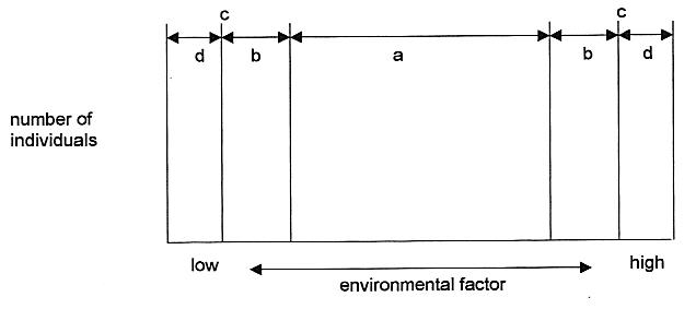
The graph below, called a tolerance curve, summarizes the responses of organisms to different levels of physical environmental factors such as temperature, moisture, pH, altitude, etc. The x-axis (along the bottom) represents the range of the environmental factor. The y-axis (along the left side) represents the number of individuals of that species that survive at a given level of the environmental factor.
The graph is subdivided into 5 zones. The center zone, labeled a, is called the optimal range. This is the range of conditions under which the organism survives best. The zones labeled b are the stress zones. The organism can still survive under these conditions, but not as well as in the optimal range, so fewer individuals can survive under these borderline conditions. The zones labeled d are the lethal zones. Conditions here are so bad that no individuals of the species can survive in them. The border between the stress zones and the lethal zones are called tolerance limits. The tell us the minimum and maximum limits of tolerance of the organism for this particular environmental factor.
We have discovered a few organisms that can tolerate conditions we once thought would be fatal. They are called extremophiles because they seem to love extreme conditions. Many of them are bacteria that live in volcanic vents in the ocean floor or in hot springs. The organisms that can survive extremes of hot, cold and dry have evolutionary adaptations that allow them to survive. We have even exploited some of the thermophilic bacterial enzymes to amplify DNA. Another extremophile called a tardigrade can survive desiccation (drying out) for decades. It does this by inserting special molecules in its membranes that protect it during dry conditions. Scientists are trying to exploit this ability to prevent damage during cryopreservation (freezing at very low temperatures).
read Figure 44.15 on page 940-941
II
. factors affecting terrestrial species distributionRemember that in physical biogeography, species distribution is based on physical factors. Those factors differ considerably for terrestrial and aquatic species, so we will consider them separately. In this section, we will look at the effect of climate and nutrients on the distribution of terrestrial species.
A. climate
Climate has two main components: temperature and precipitation. Both of these vary in different parts of the earth due to several factors, although not necessarily the same factors for both. Ocean currents and wind patterns modulate basic temperature and precipitation patterns, mostly by redistributing air and water.
1. temperature
Temperature limits the distribution of species because if it is too low it lowers an organism's metabolism too much for it to maintain cellular activity. In extreme cases, the formation of ice crystals inside cells when they freeze damages the cell so that even if it thaws out, it cannot survive. On the other hand, temperatures that are too high cause damage to proteins in the organism's body, a condition that can also be fatal.
The temperature in any given place on the earth depends mainly, but not exclusively, on its latitude and its altitude:
a. effect of latitude
As you move either north or south from the equator, two things happen to make the temperature decrease:
1) solar radiation is spread over a larger area due to angle of incidence of solar radiation
2) solar radiation has to pass through more or the atmosphere before it hits the earth's surface
Figure 50.4 on page 1031 illustrates these effects of increasing latitude.
In general we can divide the Northern and Southern Hemispheres into three zones each.
|
latitude |
name of zone |
seasonal changes in temperature |
|
0 to 30 |
tropical |
minor* |
|
30 to 60 |
temperate |
moderate |
|
60 to 90 |
polar |
extreme |
* may have wet and dry seasons instead of warm and cold seasons
b. effect of altitude
As you move up from mean sea level, the temperature generally decreases. This is because as you go higher, the atmospheric pressure decreases, which means the air is less dense (there are fewer molecules per liter), and that means that the molecules of the air cannot hold as much heat.
c. effect of ocean currents
Ocean currents are defined as the movement of surface water caused by the rotation of the earth and the action of wind on the water. The currents affect air temperature in coastal more strongly than inland areas. The Gulf Stream is a current in the North Atlantic Ocean. It sweeps downward past Africa, then turns when it reaches the equator and moves westward towards South and Central America. Those land masses in turn deflect the current northwards along the eastern coast of the United States. From there it continues eastward across the Atlantic towards Europe, which deflects it southwards past the coast of Africa. It makes a big clockwise circle in the North Atlantic Ocean. As it flows along the equator, the water warms up. Later, when this warm water moves along the eastern coast of the U.S. and past Europe, it gives up some of the heat. The climates of the coastal areas that are passed by the Gulf Stream are much warmer and more mild than they would be expected to be based only on their latitude and altitude.
Another example is the Humboldt current. It carries cold polar water from the Antarctic up past the western coast of South America. The effect there is to make the climate cooler than would be expected based on latitude and altitude.
2. precipitation
a. effect of latitude
Figure 50.13 on page 1103 shows the effects of latitude on precipitation and wind patterns. The circular patterns in part a of the diagram are called convection cells. They are caused by differences in temperature of the air at different latitudes (the temperature differences are explained above). At the equator the sun has its greatest effect, and it heats up the air which rises. It also evaporates water from the surface into the air. So as warm moist air rises near the equator, the water cools and condenses and falls as rain. Therefore, areas close to the equator have high rainfall.
The much dryer air continues to rise, and is forced to turn north or south. At about 30 degrees north and south of the equator, the air descends. This is called a subsidence zone. Most of the deserts of the world lie near 30 degrees north or south because of the dry air. There is another high precipitation zone around 60 degrees latitude.
b. effect of rain shadows
Rain shadows are illustrated in figure 50.14 on page 1104. They exist in areas where mountain ranges block the prevailing winds coming inland from the ocean. The situation in the diagram represents what happens on the west coast of North America. As air moves eastwards over the Pacific Ocean, it picks up evaporating water. The moist air moves over the mainland, but runs into the mountain ranges. To get past the mountains, the air has to go over them. This cools the air, and a lot of the moisture in the air condenses and falls as rain on the windward side of the mountain range (windward means the side the wind is coming from). The air that gets over the mountains is very dry, and it usually causes dry conditions and even deserts on the leeward side of the mountains (leeward means the side away from the wind). Thus we have a lush temperate rain forest on the coast of Washington and Oregon, and farther inland on the other side of the mountains there are very dry conditions, almost like a desert.
3. wind
The main effect of wind is to affect the distribution of moisture in the atmosphere. The effect of convection cells on wind is illustrated in figure 50.13. Surface winds between the equator and 30 degrees flow towards the equator. In the temperate zone (30 to 60 degrees) surface winds flow away from the equator. And in the polar zones they flow towards the equator again.
If this were the only factor affecting wind direction, most parts of the world would have northerly or southerly winds most of the time. There is another important force that alters the patterns caused by convection currents. It is called the Coriolis effect and it is caused by the earth's rotation acting on the northerly and southerly winds. It causes surface winds going south to be deflected slightly to the west, and surface winds going north to be deflected towards the east.
B. nutrients
Nutrients are materials used for growth and maintenance in living things. In terrestrial systems, plants get their nutrients from soil, and animals get their nutrients from plants. So we all depend, either directly or indirectly, on the soil. The major nutrients that plants require are nitrogen, phosphorus and potassium. They also need several trace minerals such as calcium, iron, magnesium, etc.
Soil consists of pulverized rock and organic materials but it also contains living organisms, water and air. The nutrient content of soil depends on the mineral content of the rocks it is made from and the amount of organic material it contains. Some types of rock have very high or low levels of some minerals, so soil made from them might be deficient in one or more nutrients. The organic material of soil consists of dead plants and animals and animal feces. Decomposer organisms like bacteria and molds break down dead organisms into chemicals that can be used by living plants, so many of the nutrients are being recycled (more about this in Unit 5). The living organisms in soil perform many important functions. Bacteria convert nitrogen into a form that plants can use, decomposers recycle dead organisms, worms and ants constantly mix soil components by their constant digging and tunneling. The spaces made by these organisms allow air and water to enter the soil more easily. Even large animals that dig burrows help to mix soil components
C. reality check
What was the point of all the climate and soil stuff? That plants can only live in areas where these factors match their tolerance limits, and animals have to live where there are plants to eat.
read: "Abiotic factors affect the distribution... " on pages 1100-1105
"The geographical distribution of…" on pages 1112-1113
III
. factors affecting aquatic species distributionAquatic organisms live in the water as we live in the air. Some of the factors limiting their ability to survive are: light, temperature, nutrients, osmolarity, salinity, pressure, and oxygen. Figure 50.15 on pg 1104 illustrates zonation in aquatic systems based on light availability and temperature.
Lake stratification (fig. 50.15) occurs in temperate lakes in a cyclic pattern. Generally in the winter the surface is frozen, but that insulates the lower water where organisms can survive. In the spring when the ice melts, the cold surface waters sink, mixing up the water. This is beneficial because it takes oxygen to the bottom and brings up nutrients to the surface. During the hot summer, warm surface waters don't mix with cooler bottom waters. Nutrients tend to be depleted in the surface layer and oxygen tends to be depleted in the bottom. In the fall, cooling of surface waters causes them to mix again and redistribute both nutrients and oxygen. You can see that organisms like fish that need a lot of oxygen are restricted to certain parts of the lake during the winter and summer especially. And phytoplankton (algae) can only survive where there are both sufficient light and nutrients. Light is present close to the surface, but nutrients are usually higher around the shores and on the bottom. In the summer, algae may have a hard time because the nutrients are depleted in the photic (surface) zone.
Oxygen levels are important to animals living in aquatic systems. In general, colder waters have higher levels of oxygen dissolved in them. Surface water may have higher oxygen levels because oxygen diffuses from the air directly into the water. Mixing, which occurs in shallow areas where water runs over rocks, helps to dissolve more oxygen in the water. Nutrients have an very important effect on oxygen levels. in lakes and rivers with high nutrient levels (eutrophic), algae populations explode in warm weather. At a certain point, they have taken up most of the nutrients in the water and the algae begin to die. Decomposers (bacteria) start breaking down the dead algae, a process that requires oxygen. So the decomposer bacteria use up the oxygen. Then other organisms that need oxygen die also. This is what happened in Lake Washington. In lakes and rivers with low nutrient levels (oligotrophic), algae never grow explosively, and the problem of oxygen depletion doesn't exist.
IV
. aquatic and terrestrial biomesThe word biome technically refers to terrestrial communities characterized by a dominant type of vegetation (rain forest, desert, grassland). Many biologists have expanded the definition to refer to any characteristic community type, whether terrestrial or aquatic. In general then, the word biome means a major type of ecosystem, characterized by a certain range of environmental conditions (temperature, precipitation, salinity) and including a set of characteristic organisms. You will need to be familiar with the biomes described in chapter 50.
read "Aquatic and Terrestrial Biomes" on pages 1106-1116.
You should be able to define these terms:
biogeography
tolerance
convection cell
rain shadow
coriolis effect
decomposer
eutrophic
oligotrophic
biome
photic zone
aphotic zone
littoral zone
limnetic zone
wetland
estuary
intertidal zone
You should be able to interpret and explain the content of these diagrams or tables:
50.10
50.11
50.12
50.13
50.14
50.15
50.17
50.18
50.19
50.22
50.23
50.24
50.225
You should be able to answer these questions:
1. Compare physical, evolutionary and island biogeography.
2. Explain tolerance and how it can be used to predict species distribution. Draw, label and explain a tolerance curve.
3. Name the major physical factors that affect terrestrial species distribution.
4. Describe the effect of
a. latitude on temperature
b. altitude on temperature
5. Describe the effect of
a. latitude on precipitation
b. rain shadows on precipitation
6. Discuss the major global wind patterns.
7. Explain what causes ocean currents and explain their effect on climate.
8. Discuss the effect of
a. soil on the distribution of terrestrial organisms
b. water nutrients on the distribution of aquatic organisms
9. Describe the process and results of lake stratification.
10. For each aquatic and terrestrial biome described in Chapter 50, be able to discuss any unique features (like permafrost in the tundra), the physical factors that are typical for that biome (temperature, rainfall, etc.) and typical organisms found in that biome.